Author of Blog: Daniel Day

Showing posts with label TX. Show all posts

Wednesday, December 10, 2014

Streetcar IV: The Future of Rail in SA

29-1

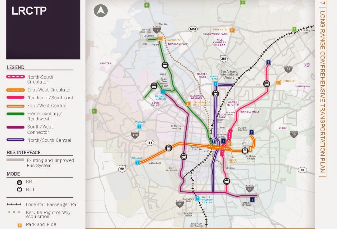
As the year comes to a close, and the streetcar is a goner, what does the future of rail transit look like for San Antonio?  If you ask the average San Antonian on what they want to see in rail transit, they'll say that San Antonio needs a subway, or a monorail system which stretches from downtown to at least loop 410 or even 1604.  They will not say Light Rail, or Commuter rail although if you show them the plans collecting dust on the Austin/San Antonio Commuter Rail, they'll, we'll all say we need it now.  The same I've notice if you take any San Antonian for a ride on a light rail vehicle in either Houston (Image 29-1) or Dallas. (Image 29-2)  Via has plans on the books for a two route light rail system, (Image 29-3) but I doubt that we'll ever see it and recently from the latest 25 year long range meetings that the Alamo Area MPO held, they extended the North/South Study area to the Stone Oak Area. 

But guess what San Antonio, We'll never ever, and I mean ever get a subway or a monorail system here because we don't want to pay for it.  If you venture to lightrailnow.org, you come across the article called "New subway (metro) systems cost nearly 9 times as much as light rail."  In this story they site Buffalo's LRT system and how light rail vehicles are using the tunnels, not the famed subway vehicles we see on TV shows.
Quote from Story:
"But the “why not a subway?” issue keeps rearing its head — mainly reflecting the resistance of the motor-vehicle-focused mindset to having urban space, especially street space, shared or usurped by mass transit operations. Overwhelmingly, surface LRT in one type of alignment or another (from street reservations to the re-use of abandoned railway corridors) has triumphed … although there have been cases where pressure to “build it out of sight” has forced new LRT startups underground (or even canceled planned projects altogether).
The tremendous investment cost of digging a subway and installing underground stations is obviously a huge deterrent to the development of such systems — both in the initial financing, and in sopping up available resources that could otherwise be plowed into vigorous expansion of the system. Buffalo’s 6.4-mile LRT line, for example, was constructed almost entirely (81%) in subway … and hasn’t been expanded one foot since its original opening in 1985."
29-2

Dallas also has a subway tunnel too and they originally planed to build a subway line only to give up and turn it into tunnel for their 90+ mile light rail system. (Image 29-2)  But when we look to Dallas for inspiration, we forget what they had and we do not, a very friendly former US Senator named Kay Baily Hutchinson to provide federal funding.  So these stories are any indication if we ever dig a tunnel for rail in San Antonio, chances are that we'll have a light rail vehicles operating in it. Another thing Dallas has going for it was a good number of abandoned rail lines crisscrossing the city to put down the light rail tracks.  San Antonio on the other hand lacks these abandoned rail lines to put any light rail system down, so as I've stated before in other blog post that if San Antonio is to get any light rail, it will mostly go down the big stroads in San Antonio as is indicated on the planning maps.


Now we hear all the time that we want a Monorail system just like, no better than the one at the 68 Worlds Fair.  Well as I looked into monorail system on Wikipedia, I found a disturbing trend.  You see, all these monorail systems seem to be short, I mean streetcar short unless they were in China.  Out of all the systems that Wikipedia list, the longest in North America is in Las Vegas. According to the Wikipedia article, it doesn't even enter the city of Las Vegas.  The most famous one in Seattle is quite short, barely a mile. So if these three systems are any indication that if we ever build a monorail system, chances are we won't get one connecting Loop 410 to Downtown.

I could waste my time and point out the failures of Personal Rapid Transit, but here's the thing, we have such a system already in place, it's called driving your car. So if someone tries to sale it to you this, chances are they're from a think tank that gave us Obamacare, like Heritage or Cato. 

Now if we really want to see how rail transit will most likely look here in San Antonio, we have to look to the City of Weird as in Keep Austin Weird for they are the closest city to us and the most similar community when it comes to driving habits and in the number of times begging the Federal Government for transit funding.  Recently Austin, had a proposition that failed that would have brought Light Rail roughly along I-35.  Now it's funny how it died because if you were to just count the votes along the proposed rail line, it would have won.  Now not all the anti rail advocates were against it because it was rail, but because where it would have not been built along Lamar.  The same sadly will happen here in San Antonio for when it goes to the ballot, everyone except the ones that live along the proposed route, will vote against it unless the voting happens to take place during a presidential election. 

Currently Cap Metro operates a 32 mile Commuter rail (Image 29-4) from Leander to Austin's Convention Center downtown, Monday through Saturday.  In 2004, Austin voted to add rail along it's freight railroad tracked it own.  Only after much delay, it started Operations in March 2010.  Since then an average of 2,500 trips take place daily and it's full of critics from on where it's located, to it doesn't serve enough people.  My criticism on it is that it don't operates to 10 or 11PM everyday.

29-3


This is what San Antonio's future rail system is going to looks like because we don't want to slow down traffic for it, we don't want to vote yes for it, and most of all, we don't want to pay for it.  The future is sighted on Via's 25 year long range plan map called the Kerrville right-of-way Acquisition.  On this map, you'll see a grey dotted line snaking from the Westside Multimodal Center to Fiesta Texas and it's not I-10, but a railroad track currently a freight line that roughly parallels I-10 and use to go all the way north to Kerrville and Fredricksburg.  Today the Rail line dead ends at the Rim, and if you go there, you'll see a rail yard full of hopper cars.  This terminal is used by Martin Marietta Materials, the company that dug out the quarries that Fiesta Texas, the Rim are currently located in.  I don't know when they'll be finished with their digging, but it should come a close some time around 2020. Once the freight operations cease, Via has plans to buy the rail line.  Whether they choose to keep it operational as a freight line like Cap Metro is up in the air, but they'll definitely peruse an option to put some type of passenger rail on these tracks.
29-4

Whether they use the same diesel Multiple Units (DMUs) (Image 29-4) as Cap Metro is up in the air, but more than likely, they will and I cannot say how many stations there would be, but I can at least guess that the stations will probably be at the following locations:
  • The Rim/Loop 1604
  • De Zavala/Huebner/Wurzbach
  • Loop 410
  • Basse Rd/Hildebrand
  • Fredricsburg Rd
  • And finally Westside Multimodal Center
29-5

And chances have it, that they will try to expand it further south along to Blue Star and down the Railroad track that currently delivers coal to the CPS coal generators at Calaveras Lake (Image 29-5) and even down to Elmendorf.  I bet once they have it operational, there will be some talk of extending it to Beorne or even Kerrville and Floresville, but I can bet it will all be TALK for the money will never ever be available unless they change the funding of this rail line from the current begging for federal and state funding to doing something that we use to do in funding transportation, which is Land Value Added tax.  We use to use this method to fund all our transportation needs way before a gasoline tax.  When they built a electric trolley line or a new rail line the property along the way would go up in value and that added value would go towards the maintenance and operation of that rail line.  I hear this is how they currently fund transit system in Japan, but that is something I cannot confirm nor provide a link to.  By judging how we currently fund our transit which is not by bus fare, but by a 1/2 cent sales tax, it don't think it's a working for everyone believes at some level that Via Sucks. 
29-6

Union Pacific Railroad will also stand in the way like one of their freight trains blocking traffic at a railroad crossing.  They dragged their feet when it came to the linear creekway trails going underneath their railroad tracks.  I'm personally counting on Union Pacific to seal those feet in cement to prevent that train from getting next to the Westside Multimodal Center, (Image 29-6) and even further to Blue Star and Elmendorf.

It will be fun to watch as the years go by hearing the same things over and over again, how San Antonio needs a subway, and lacks the political will to get rail transit done, but I can be assured up to my death, to point this out in the years to come in future blogs that isn't the case so much as your methods of selling what could be best to the general public. Chances are they'll be naysayers will say that buses can do a better job, but if that's the case then why in my video I created that it's way easier for the wheelchair to get aboard the DART Light Rail Vehicle instead of the Via Bus?  As always work to Keep San Antonio Real, realize that we all end up Keeping San Antonio Lame by making sure cars can move faster than transit, and keeping it easier to drive an automobile than riding a bicycle or walking.

Images:
29-1:  Houston Metra Downtown Transit Station Looking north.  From the video....http://youtu.be/aQmPnTjegJ8
29-2:  DART Light Rail Garland Station Looking Southwest.  From the Video...http://youtu.be/YV2ksedrTjo
29-3:  Via's 25 long Rang Plan Map.  Originally posted in Mr Nirenberg, Ever think of Walking? as Image 20-2.  Map can be found on PDF format at http://viainfo.net/Planning/LRCTP.aspx
29-4:  Austin's CapMetro Commuter Rail DMU arriving at Highlands Station.  From the Video...http://youtu.be/PmrjyXCxqzU
29-5:  A picture of the Railroad Tracks along S Presa and Southcross where currently goes out to the CPS Energy coal plant at Lake Calaveras and Dead ends just South of Loop 1604 along Old Corpus Christi Rd right Before Saspamco.
29-6.  Picture from the W Commerce St Overpass of the Westside Multimodal Center looking north referring to a prediction that UPRR will prevent any future rail from accessing the old Train Station. 

Wednesday, October 1, 2014

San Antonio Barely Makes the List

21-1
Every two years, Bicycling Magazine creates this list of the 50 top bicycle friendly cities in America published in Oct 2014. We're down to #48 (Image 21-1) from #47 back in July 2012 (Image 21-2).  83 Miles north of us, is the Weird city of Austin, and they're also on the list at #11 from #13 back in 2012 (Image 21-3).  Another blogger recently wrote about this in Fit In S.A. saying quote: "The completion of the Mission Reach is one of the reasons San Antonio made it onto the list." That's the only reason why we're even on the list folks because of a "recreational trail" and with B-cycle serving it.

21-2
Don't get me wrong I love the Mission trail, but unlike back in 2012, Bicycling Magazine also mentioned the bicycling community quote: "An emerging cycling-friendly vibe fueled by 1,700 miles bike network of lanes, paths, and sharrows."  What the hell happened, oh, that's right, the City council voted for the removal of such a system with only one member, Shirley Gonzales voting to keep it.  Also happened was that Boneshakers got it's property cut off by the San Antonio River Authority, and they went out of business at their river location and their Hays Street Bridge location. Cars still park in the cities only cycletrack on Avenue A, and to top it all off, the city don't give a damn about cars parked in your bicycle lane.

21-3
But I don't think it is because of our expanding B-cycle or a completed recreational trail that we made the list, in my own opinion I believe it is the fact that San Antonio has a rich bicycle culture.  It is you the people who come out to Frankenbike, Downtown Highlife Bicycle Club Ride , the Zombie ride, and all the other rides in San Antonio.  It's bicycle groups like The Wild Dawgs, the Street Ratz and many many more.  It's those who get on their bicycle or as I like to say "put the fun between your legs," and ride everywhere just because.  You see it every First Friday with people just riding down S Alamo and going to the bicycling friendly places like Alamo Street Eats, and other bicycle friendly places like the Bottom Bracket Social Club.

21-4
It's funny as I look back at our position of #47 and see an echo of it through the Tweet of Diego Bernal of District 1 claiming how San Antonio is planning to 1,700 miles of bike lane (Image 21-4).  Just like Ron Nirenberg saying how we need a plan to improve transportation in San Antonio, it goes to show you how useless it is to have a plan if your not willing to follow through. 

Recently, Several Stroads where recently repaved in District 1 near downtown.  Here on Colorado St, they finish repaving it and repainting it (Image 21-6).  According to the Bicycle Master Plan, Colorado St from I-10 to Caesar Chavez (Image 21-5) has a plan for a road diet similar to what was done to S Flores. But as you can see in my recent photo of the place it has the same configuration that makes a stroad a stroad.  Hey Mr Bernal, where's the bike lane that you promised? (Image 21-4) 
21-5
21-6

But lets face the reality here, San Antonio is too stuck behind the wheel of a car to ever envision a Netherlands network of bike paths and Cycletracks or ever have light rail transit.  Although the city is constructing a cycletrack in front the Henry B Gonzales Convention Center along I-37, chances are it won't be used like the city ever intended because there's no signs, sharrows, or painted green like you would see on a similar path in Austin (Image 21-7).  If things don't start changing, we will not be on the Bicycle Magazine list come 2016 while I'm betting that Austin will be comfortably in one of those top ten positions because they're committed to building more bus stop islands like this one on Guadalupe St (Image 21-7).  Keep Austin Weird, Keep San Antonio Lame.
21-7
Images:
21-1:  A picture of the Bicycle Magazine October 2014 rating of San Antonio, TX as #48 of one the top 50 Bicycle  Friendly Cities in the USA.
21-2:  A picture of the Bicycle Magazine July 2012 rating of San Antonio, TX as #47 of one the top 50 Bicycle  Friendly Cities in the USA.
21-3:  A picture of the Bicycle Magazine October 2014 rating of Austin, TX  as #11 of one the top 50 Bicycle  Friendly Cities in the USA.
21-4: A Screenshot of my Facebook Re-posting of Diego Bernal's FB posting of how San Antonio has 1,700 miles of bile lanes planned and my friends response to his comment.
21-5: A Screenshot of page 28 of the Bicycle Network PDF of the Bicycle Master Plan.
21-6:  Colorado St Looking North one block north of Martin St.
21-7:  The Bus Stop Island on the Guadalupe St Cycletrack in Austin, TX.

Tuesday, July 22, 2014

Iowa St Bike Lane, a Double Edge Sword.

Go Fund Me Campaign


It still up, and I could use the help to be able to take some pictures I need to illustrate the my story on the Streetcar issue.  It's going to be a three part story, and the first of these stories should be posted some time around August 6th.  If you want to help me out, please help pay for my Greyhound ticket at http://www.gofundme.com/b8rmq4

Iowa St Bike Lane, a Double Edge Sword.  

Iowa St got it's bike lane about a year ago.  But my question is, did it ever really need it?  In all my time riding up and down the this street, I never had a problem with people driving by.  In fact, even before the bike lane painting, I would have said, this is a street that never need one in the first place, then again I'm an experience cyclist, please try this at home.  LOL. 
15-1

Iowa St got painted a bike lane with 10 ft driving lanes in the center, the 4ft bike lane and then a 8 ft parking lane.  (Image 15-1)  I personally don't like this type of bicycle lanes because to a cyclist, it feels like we're riding between two buses like this cyclist is doing in  England.(Image 15-2)  On the other hand, when there are no cars parked, it becomes a buffered bicycle lane providing more protection to cyclist using it for it forces the motor vehicles to the center of the street, hence, the double edge sword. 
15-2

The bike lane on Iowa St stretches from New Braunfels down to Cherry St, the pattern of Bike lane and Parking Lane exist, but between Cherry and Hackberry, it boggles the mind on why they have this same pattern between Hackberry and Cherry because I have never seen cars parked here before there was a bike lane. Why the city of San Antonio couldn't just put in a painted buffered bike lane (Image 15-7) between Cherry and Hackberry is beyond me, but then again, when has TCI ever did something that wasn't in line with keeping San Antonio lame.

15-3
When they first put in the lanes, the 30-28 lineup I ride would ignore the bike lanes and treat it as if the four lane stroad was still there. This is nothing new, VIA ignores it's customer base all the time, just look at what the VIA supervisors do at night during the lineup on Commerce St with their trucks.(Image 15-3)  The Good news is that most of the bus drivers have stop driving the bus down the right parking/bike lane. 

If anyone from VIA is reading this, please be advise that the driving lanes on Iowa are only 10ft wide.  Last I checked, aren't those lanes suspose to be 11ft wide for safety?  I mention this because this is what I've been told at the BMAC meeting when concerning streets the buses would be running on.(Image 15-4)
15-4
15-5
Now it's not uncommon to see these types of lanes.  For example, we see it on other streets such as Ashby, Josephine, S Main, (Image 15-5) Dewey and Cincinnati just to name a few, and each time, the parking lane is bigger than the tiny bicycle lane provided.  Now it is appropriate to have it on streets like Cincinnati and Iowa, but having it down streets like Josephine and Ashby is not because of  the fast moving traffic.  If the parking was removed on these streets, then it would be better for the cyclist using it, but because the parking is more important, the cyclist will get no such relief because parking is more important than a healthy city.  At least in Austin, they actually go out of the way and have a 5ft bike lane with a parking lane next to it that even bigger.  To accomplish this, they remove the parking on the other side of the street.  (Image 15-6)
15-6
15-7
 Now if you happen not to be in Austin and encounter one of these type of streets while riding, just go ahead and ride your bicycle in the parking lane.  You have all that unused space, so put it to good use.  The City of San Antonio is allergic to removing parking, so if and when we get over that allergy, we're not going to be seeing bike lanes like this (Image 15-7) any time soon on Ashby and Josephine. 


Images:
15-1:  Iowa St by the YMCA looking West
15-2:  A Facebook photo that was shared to me.  Had to use it for it illustrates what a cyclist feels when riding next to a parked car and traffic is passing by.
15-3:  VIA's Supervisors Pickups parked on the Sidewalk next to the Alamo One Building on E Commerce St.
15-4:  A VIA Bus going down Iowa St.  Showing how the traffic lane is too small for commercial vehicles.
15-5:  The Bike lane/Parking Lane down S Main Ave looking south.
15-6:  A Similar design in street dieting but with a bigger bike lane.  Somewhere in East Austin, TX
15-7:  A painted Buffered Bike lane in East Austin, TX.  I think is looking south.


 Up Coming Important Meetings
If you want to make a difference, please attend. 


Lee's Creek, Joe Ward and Sunset Hills Parks Plan Review Public Meeting
When:  Wednesday, August 20, 2014 6:00 PM
Where:  Joe Ward Community Center,  435 E. Sunshine, San Antonio, TX 78228
What Should You Ask For:  The thing to ask for at this meeting are good sidewalks,  20 mile per hour speed limits and safe ways to get to the park down Hillcrest and St Cloud such as bike lanes down those stroads.  

Hemisfair Public Work Session:
When:   Tuesday, July 29, 2014  6PM-8PM
Where:  The Depot at Sunset Station, 1174 E Commerce, San Antonio, TX
What Should You Say:  The biggest thing is having cars come into the park.  This is the worse decision ever for if anybody know from experience, cars make a place unsafe and make people uncomfortable.  They don't let cars into La Villita, so why should cars be allowed here.  Also asking for La Villita types shops in the abandoned houses would be a plus too. 

Local Bike Advocate Training for Statewide Campaigns:

When:   August 3, 2014 1pm to 4pm
Where:  BikeTexas.org HQ  1902 E 6th St, Austin, TX  78702  or Online.  To Register, click here
Description: 
Do you want to learn key tactics to support bicycle advocacy in your area? Join people like you from around Texas for a special bike advocate training on Sunday, August 3, from 1-4 PM.
National experts from the League of American Bicyclists and the Alliance for Biking and Walking will facilitate the workshop. They'll talk about statewide campaigns in the lead up to the 2015 legislative session, such as keeping TxDOT from moving funds away from programs designed to build bicycle and pedestrian infrastructure. Register for this training and be prepared for the next call to action!
The training will take place in our office at 1902 E 6th St (map), but you don't have to be in Austin to attend. Register as a teleconference attendee and we'll send you a link to join the broadcast. Please register by July 26 to secure your spot and receive updates on the training. See you on August 3!
This workshop is offered free of charge thanks to funding from Advocacy Advance. Please consider making a donation to BikeTexas to support better bicycling in Texas. Even a dollar helps!.  More info can be found at http://www.eventbrite.com/e/local-bike-advocate-training-for-statewide-campaigns-tickets-12258432301

Up Coming Bicycle Events


 Cycle In-Cinema .  
When:   Every Thursday, June-August at Dusk, 8:45pm
Where:  Main Plaza, 115 N Main Ave, 78205
Description:  Out Door Movie.  


FrankenBike #51
When:   Saturday August 16, 2014  10AM to 4PM
Where:  Earn A Bike Coop ~ 2619 Guadalupe St ~ 78207
Description:  San Antonio's Bicycle Swap Meet and Flea Market.

Glow Roll SA
When:  Saturday July 26, 2014 3PM  Ride Starts at 9PM
Where: Travis Park Downtown.
Description:  The KickStand SA & SA Made by Hand Mercado presents "House Party in the Park @ Amor y Arte" & the 1st Glow Roll Social Ride in Downtown San Antonio

Date: Sat.July 26th
Destination: THE N. ST. MARY'S WALKABOUT event
What to do: Trick out all or parts of your bicycle with neon lights, or neon/glow in dark tape! Wear bright,neon,glow in the dark clothing for the ride too!
What to bring: ID, $$, extra tubes in case, bike and YOURSELF ready to have fun!
READY! SET! GLOW!
WHEELS DOWN @ 9:00PM!

**Amor y Arte: 3p-9p -- come by early to check out local artisans, live music & food trucks! SAMBH is providing a limited supply of glow sticks to decorate bikes. They will be set out @ 7:30p at The KickStand SA table...get there early to grab a few! Alamo Bike Shop will be set up offering tire service/minor adjustments too!