Author of Blog: Daniel Day

Showing posts with label San Antonio Streetcar. Show all posts

Wednesday, December 10, 2014

Streetcar IV: The Future of Rail in SA

29-1

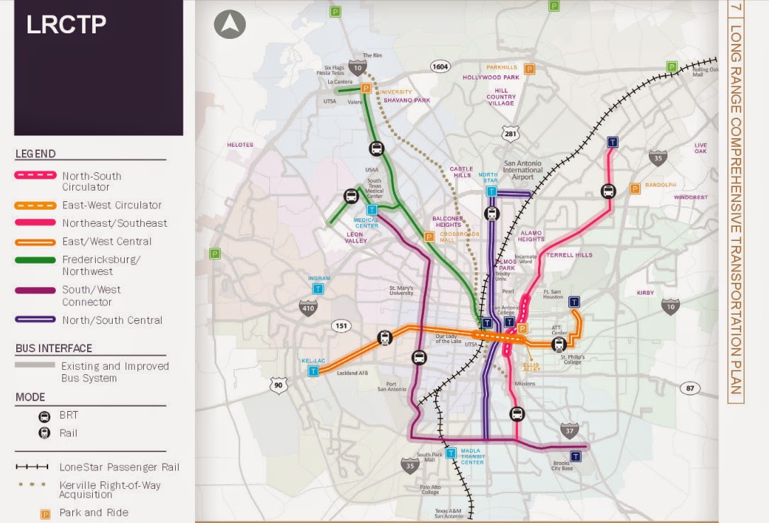
As the year comes to a close, and the streetcar is a goner, what does the future of rail transit look like for San Antonio?  If you ask the average San Antonian on what they want to see in rail transit, they'll say that San Antonio needs a subway, or a monorail system which stretches from downtown to at least loop 410 or even 1604.  They will not say Light Rail, or Commuter rail although if you show them the plans collecting dust on the Austin/San Antonio Commuter Rail, they'll, we'll all say we need it now.  The same I've notice if you take any San Antonian for a ride on a light rail vehicle in either Houston (Image 29-1) or Dallas. (Image 29-2)  Via has plans on the books for a two route light rail system, (Image 29-3) but I doubt that we'll ever see it and recently from the latest 25 year long range meetings that the Alamo Area MPO held, they extended the North/South Study area to the Stone Oak Area. 

But guess what San Antonio, We'll never ever, and I mean ever get a subway or a monorail system here because we don't want to pay for it.  If you venture to lightrailnow.org, you come across the article called "New subway (metro) systems cost nearly 9 times as much as light rail."  In this story they site Buffalo's LRT system and how light rail vehicles are using the tunnels, not the famed subway vehicles we see on TV shows.
Quote from Story:
"But the “why not a subway?” issue keeps rearing its head — mainly reflecting the resistance of the motor-vehicle-focused mindset to having urban space, especially street space, shared or usurped by mass transit operations. Overwhelmingly, surface LRT in one type of alignment or another (from street reservations to the re-use of abandoned railway corridors) has triumphed … although there have been cases where pressure to “build it out of sight” has forced new LRT startups underground (or even canceled planned projects altogether).
The tremendous investment cost of digging a subway and installing underground stations is obviously a huge deterrent to the development of such systems — both in the initial financing, and in sopping up available resources that could otherwise be plowed into vigorous expansion of the system. Buffalo’s 6.4-mile LRT line, for example, was constructed almost entirely (81%) in subway … and hasn’t been expanded one foot since its original opening in 1985."
29-2

Dallas also has a subway tunnel too and they originally planed to build a subway line only to give up and turn it into tunnel for their 90+ mile light rail system. (Image 29-2)  But when we look to Dallas for inspiration, we forget what they had and we do not, a very friendly former US Senator named Kay Baily Hutchinson to provide federal funding.  So these stories are any indication if we ever dig a tunnel for rail in San Antonio, chances are that we'll have a light rail vehicles operating in it. Another thing Dallas has going for it was a good number of abandoned rail lines crisscrossing the city to put down the light rail tracks.  San Antonio on the other hand lacks these abandoned rail lines to put any light rail system down, so as I've stated before in other blog post that if San Antonio is to get any light rail, it will mostly go down the big stroads in San Antonio as is indicated on the planning maps.


Now we hear all the time that we want a Monorail system just like, no better than the one at the 68 Worlds Fair.  Well as I looked into monorail system on Wikipedia, I found a disturbing trend.  You see, all these monorail systems seem to be short, I mean streetcar short unless they were in China.  Out of all the systems that Wikipedia list, the longest in North America is in Las Vegas. According to the Wikipedia article, it doesn't even enter the city of Las Vegas.  The most famous one in Seattle is quite short, barely a mile. So if these three systems are any indication that if we ever build a monorail system, chances are we won't get one connecting Loop 410 to Downtown.

I could waste my time and point out the failures of Personal Rapid Transit, but here's the thing, we have such a system already in place, it's called driving your car. So if someone tries to sale it to you this, chances are they're from a think tank that gave us Obamacare, like Heritage or Cato. 

Now if we really want to see how rail transit will most likely look here in San Antonio, we have to look to the City of Weird as in Keep Austin Weird for they are the closest city to us and the most similar community when it comes to driving habits and in the number of times begging the Federal Government for transit funding.  Recently Austin, had a proposition that failed that would have brought Light Rail roughly along I-35.  Now it's funny how it died because if you were to just count the votes along the proposed rail line, it would have won.  Now not all the anti rail advocates were against it because it was rail, but because where it would have not been built along Lamar.  The same sadly will happen here in San Antonio for when it goes to the ballot, everyone except the ones that live along the proposed route, will vote against it unless the voting happens to take place during a presidential election. 

Currently Cap Metro operates a 32 mile Commuter rail (Image 29-4) from Leander to Austin's Convention Center downtown, Monday through Saturday.  In 2004, Austin voted to add rail along it's freight railroad tracked it own.  Only after much delay, it started Operations in March 2010.  Since then an average of 2,500 trips take place daily and it's full of critics from on where it's located, to it doesn't serve enough people.  My criticism on it is that it don't operates to 10 or 11PM everyday.
29-3


This is what San Antonio's future rail system is going to looks like because we don't want to slow down traffic for it, we don't want to vote yes for it, and most of all, we don't want to pay for it.  The future is sighted on Via's 25 year long range plan map called the Kerrville right-of-way Acquisition.  On this map, you'll see a grey dotted line snaking from the Westside Multimodal Center to Fiesta Texas and it's not I-10, but a railroad track currently a freight line that roughly parallels I-10 and use to go all the way north to Kerrville and Fredricksburg.  Today the Rail line dead ends at the Rim, and if you go there, you'll see a rail yard full of hopper cars.  This terminal is used by Martin Marietta Materials, the company that dug out the quarries that Fiesta Texas, the Rim are currently located in.  I don't know when they'll be finished with their digging, but it should come a close some time around 2020. Once the freight operations cease, Via has plans to buy the rail line.  Whether they choose to keep it operational as a freight line like Cap Metro is up in the air, but they'll definitely peruse an option to put some type of passenger rail on these tracks.
29-4

Whether they use the same diesel Multiple Units (DMUs) (Image 29-4) as Cap Metro is up in the air, but more than likely, they will and I cannot say how many stations there would be, but I can at least guess that the stations will probably be at the following locations:
  • The Rim/Loop 1604
  • De Zavala/Huebner/Wurzbach
  • Loop 410
  • Basse Rd/Hildebrand
  • Fredricsburg Rd
  • And finally Westside Multimodal Center
29-5

And chances have it, that they will try to expand it further south along to Blue Star and down the Railroad track that currently delivers coal to the CPS coal generators at Calaveras Lake (Image 29-5) and even down to Elmendorf.  I bet once they have it operational, there will be some talk of extending it to Beorne or even Kerrville and Floresville, but I can bet it will all be TALK for the money will never ever be available unless they change the funding of this rail line from the current begging for federal and state funding to doing something that we use to do in funding transportation, which is Land Value Added tax.  We use to use this method to fund all our transportation needs way before a gasoline tax.  When they built a electric trolley line or a new rail line the property along the way would go up in value and that added value would go towards the maintenance and operation of that rail line.  I hear this is how they currently fund transit system in Japan, but that is something I cannot confirm nor provide a link to.  By judging how we currently fund our transit which is not by bus fare, but by a 1/2 cent sales tax, it don't think it's a working for everyone believes at some level that Via Sucks. 
29-6

Union Pacific Railroad will also stand in the way like one of their freight trains blocking traffic at a railroad crossing.  They dragged their feet when it came to the linear creekway trails going underneath their railroad tracks.  I'm personally counting on Union Pacific to seal those feet in cement to prevent that train from getting next to the Westside Multimodal Center, (Image 29-6) and even further to Blue Star and Elmendorf.

It will be fun to watch as the years go by hearing the same things over and over again, how San Antonio needs a subway, and lacks the political will to get rail transit done, but I can be assured up to my death, to point this out in the years to come in future blogs that isn't the case so much as your methods of selling what could be best to the general public. Chances are they'll be naysayers will say that buses can do a better job, but if that's the case then why in my video I created that it's way easier for the wheelchair to get aboard the DART Light Rail Vehicle instead of the Via Bus?  As always work to Keep San Antonio Real, realize that we all end up Keeping San Antonio Lame by making sure cars can move faster than transit, and keeping it easier to drive an automobile than riding a bicycle or walking.

Images:
29-1:  Houston Metra Downtown Transit Station Looking north.  From the video....http://youtu.be/aQmPnTjegJ8
29-2:  DART Light Rail Garland Station Looking Southwest.  From the Video...http://youtu.be/YV2ksedrTjo
29-3:  Via's 25 long Rang Plan Map.  Originally posted in Mr Nirenberg, Ever think of Walking? as Image 20-2.  Map can be found on PDF format at http://viainfo.net/Planning/LRCTP.aspx
29-4:  Austin's CapMetro Commuter Rail DMU arriving at Highlands Station.  From the Video...http://youtu.be/PmrjyXCxqzU
29-5:  A picture of the Railroad Tracks along S Presa and Southcross where currently goes out to the CPS Energy coal plant at Lake Calaveras and Dead ends just South of Loop 1604 along Old Corpus Christi Rd right Before Saspamco.
29-6.  Picture from the W Commerce St Overpass of the Westside Multimodal Center looking north referring to a prediction that UPRR will prevent any future rail from accessing the old Train Station. 

Sunday, August 31, 2014

Streetcar Part III, No Need for Streetcars Down Broadway.

Sorry for the wait, but as usual my life has been busy.  Since I got a new job and my hours have change, I'll be changing the publishing day to Monday or Tuesday every week and I'm still committed to publishing every week.

Also, I'll be creating two new pages, one, of important meetings that cyclist or concern citizens should attend to make San Antonio a real place, and two, one of bicycling related events that are taking place in San Antonio.  

Streetcar Part III, No Need for Streetcars Down Broadway.

Now lets get one thing strait, I was a streetcar supporter.  Why you ask, because even this slow, lousy system would be a plus to our transit system that sucks. It would have gotten some political supporters that "choice users" bring to the transit discussion that San Antonio currently lacks, and most of all, I wouldn't have to worry about a bike rack being full especially on a rainy day for I would be able to take my bicycle aboard and not just the minimum three allowed and most of all, maybe a chance to actually get a protected bike lane on Broadway.  I also felt that this was a scheme in Via's long range plan from the former CEO, Keith Parker, now in charge of Atlanta, GA MARTA in which he said, that once you build it, the people are going to change their tune from the current "rail sucks" to "when are you going to bring it to my neighborhood."  I felt that after they build it, they would have eventually either expanded the system to include more of the city like out to Loop 410 with faster speeds, or put light rail back on the ballot like back in 2000.
19-1

The more and more I heard about the development results of the streetcar, the more I felt that the goal of the Streetcar was based on the McKinney Ave Streetcar (Image 19-1, 19-2) in the Uptown neighborhood in Dallas which to me seems to be a place a lot like La Cantera. It was the dream of Mayor Hardberger to connect the Pearl with the rest of Downtown and the streetcar would have done that.

Back in September 2013, I went to Dallas to see the new transit service to the largest city that lacks transit service, Arlington, TX; although, what I found was disappointing, I also wanted to ride with the Dallas Critical Mass to get their opinion on how they deal with McKinney Ave Streetcar tracks for which they said they treat it like any other street with lots of pot holes.
19-2
19-3

That night as we rode, they took me to a place called the Truck Yard just off of Greenville Ave, and there I discovered a place that was the pinnacle of what good urbanism brings out, a First Friday every night, or at least every weekend.  For those of you who don't know what First Friday is, well think of the Pearl Farmers Market is every Saturday morning.  It was after that that I finally realize that we don't really need a streetcar to achieve development goal of what the Streetcar promised,(Image 19-3) but what we really need to do is create the foundation of a neighborhood that creates the conditions that makes a really happening place.

19-4
To create that foundation of development that was sought with the Streetcar, we need to fix the problem that is currently found on Broadway or for that matter, the entire downtown where the Streetcar was planned to travel down.

Before the big sidewalks were added, Greenville was much like Broadway is currently. A stroad with fast moving, many lanes of traffic and nothing happening along it.  Today, Greenville Ave is a place is much like South Alamo but with super size sidewalks.  Even though S Alamo lacks the big sidewalks, the concept is virtually the same, two lanes of slow moving traffic with sidewalks protected by plants or parked vehicles, and a community that is allowed to reinvent itself.  Broadway is the opposite of that with fast moving cars, multiple lanes of traffic and tiny sidewalks with no protection from traffic full of obstacles like this bus stop at Fourth and Broadway.(Image 19-4)  It's a Stroad in every sense, every space for cars, not much for anything else. We also need to fix the zoning when it comes to new development and make it more flexible, such as no parking minimums with new development.  

19-5

19-6
You can tell just by looking at the area around Greenville Ave that it's a happening place and not just by the dancing frogs on top of the Taco Cabana.(Image 19-5)  The sidewalks that are here use to be vehicle lanes (Image 19-6) and because there's a space for parking the cars along the street, it provides that barrier between the moving vehicle traffic and the pedestrian activity.  Here's my 6 minute video of the place across the street from the Trader Joes.  In this video you'll see what is making Greenville Ave a great place and what is missing from Broadway, Slow moving Traffic and good sidewalks.  

19-7
For this purpose, I'm only going to focus on Broadway and not other stroads that the Streetcar would have went down.  Now the Streetcar was planning to go as far north as Josephine St, but for our purposes, we can actually include the part of Broadway as far north as Hildebrand due to the fact that my fixes won't cost $270 million and the fact that the stroad scape is the same.  I've divided Broadway into three parts, (Image 19-7) the first part is the Broadway that has 7 lanes, 6 travel and one center turn lane is the Midtown Section.  The part goes underneath the freeway I call the 281 section, and finally, the Downtown Section from Jones to Martin, where we have useless sharrows, narrow sidewalks and to the rest of the general public, abandon buildings.  (Image 19-22)

Also for the examples, I'll be using cross sections illustrations like the one below which is how Broadway is pretty much designed today.(Image 19-8) All cross sections illustrations will face north and all lanes have been measured by me on the actual stroad in this case, Broadway. Through these cross section illustrations, I'll be demonstrating the possibilities for Broadway and use this same form for other stroads in future posts.  In this cross section illustration(Image 19-8) you see the term "bus lane."  For our purposes, this is a regular drive lane where you're most likely to see the bus traveling in.

Midtown Section
19-8

The Midtown section starts from Hildebrand Rd and goes to Casa Blanca.  I written about this section before in other blogs such as Two accidents that didn't need to happen, and #sasidewalkssuck. Here you have 1 center turn lane, and 6 drive lanes.  Much of the 5ft sidewalks in this section live up to the hashtag #sasidewalkssuck.  The Streetcar would have made the sidewalks wider along this part of Broadway, at least to Josephine, and perhaps added some parking in what is now that right 10ft lane. To improve Broadway, the cheapest thing we could do to improve this stroad is to turn that right 10ft drive lane into a buffered bike lane or a protected bike lane by poles. (Image 19-9)  By doing this we make it feel a little safer to walk and bicycle along by removing the fast moving traffic that is now next to the sidewalk.

19-9

The Problem with this design comes when we get to the bus stop.  You see, currently if a Via bus wishes to stop along Broadway with the Cheapest concept in place, it will have to invade the buffered bike lane.  So lets add a small bus stop island (Image 19-10) so the cyclist can keep cycling and the bus can stop without having to worry about running over a cyclist. 
19-10


But lets face it, if we are to really improve Broadway, the way the streetcar would have done, we're going to have to remove that center turn lane and put down some on street parking.  Here (Image 19-11) is what the city should be proposing to this part of Broadway.  I call this the "Ideally Concept" where I reduce the number of drive lanes from Current (Image 19-8) six lanes to four lanes.  I remove the center turn lane and put that space for parking on the west side of Broadway and made the sidewalks bigger.  Now remember, your always looking north on my cross sections illustrations and the reason why I put the parking on the west side, (the Witte Museum side) is because that's the side on which you'll find Brackenridge Park and businesses without on street parking for the most part.  I did my measurements for the Midtown Section in front of the Tuk Tuk Taproom, so all measurements are to that area, however, the Right Of Way, that's the Government property part of Broadway, gets a little bit bigger as you go further north so these things could be widen a bit.   
19-11
 Now to put in the bus stops with the "Ideally Concept," I put in two different versions.  On the west side of Broadway, we remove the parking lane and put in a bus stop island with Shelter.  (Image 19-12)  For the east side, since the bus stops aren't as big like the current bus stop at Lions Field park, I've decided to go  with the bus stop island being about 4ft wide.(Image 19-13)  This way, no matter what side your on, you'll always have a protected bike lane without having to worry about a bus making a stop in the bike lane.

19-12
19-13

Now Traffic flow is important for this Stroad is a major thoroughfare.  But we need less of the stroad and more of a famed Boulevard (BLVD) design.  So reducing the number of driving lanes from six to four, we reduces the current scene of cars trying to out run each other.   By reducing the travel lanes from 6 to 4 and removing the center turn lane, we also reduce the amount of distance a person on foot has to cover when they do cross Broadway from 74ft (Image 19-8) to 44ft (Image 19-12).  And with the protected bike lanes, we create a safe place for both person on foot and on bike.

281 Section
19-14
 This section as indicated in Image 19-7, is between Casa Blanca and Jones.  It's also the section underneath the interchange of I-37/US 281and I-35.  In this section, (Image 19-14) you currently have a 5ft bike lane, four 11ft drive lanes and one 10ft center turn lane.  Not much improvement needs to be done to this section, for the 5ft bicycle lanes does provide some type of barrier between the traffic and the sidewalk.  We could use some wider sidewalks, but as a cyclist, I don't want to give up on my bike lanes.  So to do this, we need to remove that 10ft center turn lane and put that 10 ft to the sidewalks and a barrier to make a protected bike lane.  We can also put in some Bus Stop Islands with out having to reduce the driving lane width and not having to reduce the walkability.
19-15

19-16
Now We've done our improvements to this Section to the street scape, we now have to figure out how to use all this green space underneath the bridges.  Has anyone ever thought as this space as a city park?  Up until about mid August 2014, there was a small pond that formed underneath one of the bridges (Images 19-17, 19-18) and across the stroad, you'll see a dog park (Image 19-16).  Here's my question, why can't we have a bigger dog park that  takes advantage of the shade that this exit ramp from I-35N to I-37S  bridge produces? And this rain water created pond, back in June and July, I saw several species of birds including a pair of Black Belly Whistling ducks with a family of duckings as well as a Green Heron gorging on tadpoles, and other bug aquatic life. (Image 19-17).  Currently the pond has dried up, but given another big rainstorm, it will be back.
19-17

19-18
19-19

City Parks and open space for that matter has been known for years helps with making people happier and healthier.  It's that touch of nature that makes city living better.  When we lack green spaces in the form of city parks, gardens and trails, we make our communities just a little bit of a dimmer place to be in and take it from me, San Antonio lacks a lot of parks for people to play and relax in. 

Downtown Section
19-20

19-21
 This is where the Streetcar would have served the entire section.  It is also the section where even though we are pretty much in downtown, we have a bunch of abandoned buildings, or at lest to the general public, they are abandoned.(Image 19-21)  It's also the section where we would have seen most of the development that the streetcar promised to delivered.(Image 19-3)  But look at what is wrong with it right now, you have an abandoned street scape with narrow sidewalks, useless sharrows (Image 19-22) with places that nobody goes to unless they work there. It's pretty much a dump even though it's like two blocks from the Riverwalk Museum Reach. Now the cheapest thing we could do to improve this section of Broadway is to remove that god awful 16ft lane with the useless sharrow/parking lane (Image 19-20) and bring back the bicycle lane, but that would make it somewhat safer for us cyclist, but that's it. (Image 19-23) And this stretch of Broadway use to have bike lanes, but somebody thought that parking was more valuable, but go there on any day of the week, and tell me, who in the hell is parking on Broadway because for the most part, I barely see two vehicles, maybe three.  If Spock from Star Trek said that "the needs of the many, outweigh the needs, of the few," wouldn't a painted bike lanes serve more people instead of just three or four individuals with parking spaces for a car?
19-22
Now I don't know what the street scape was going to look like with a streetcar, but my general feeling it would have looked something like this, with improved wider sidewalks.(Image 19-23)
19-23

Now we just don't need Improved sidewalks, we also need a zoning ordinances that will encourage the type of development that the streetcar would have brought, but before we play with the zoning ordinances, we need to make it a more comfortable place to be walking. 
19-24


We have 76ft to play with, and we could do a whole bunch of designs, but this is where I cannot decide what is the best choice for the Downtown Section of Broadway.  So the question should be asked, do you want Broadway to have flowing traffic, or do you want it to be like Greenville Ave in Dallas?  You have to remember, Broadway is one of those important corridors for the city for it is sandwich between a freeway, and a military base.  Now in all of my Cross Sections, I have a protected bicycle lane and that's simply because protected bike lanes bring out cyclist and reduce injury risk by 90% and from my experience of riding the one in Austin on Guadalupe St, it's way nicer than riding in traffic with useless sharrows.

The reason why they took out those bike lane in the first place back in 2011, was because there was no on street parking.  Well if parking is really that necessary, then this is how The Downtown Section of Broadway should be designed.  It should be designed with a Center Turn lane, two drive lanes and two parking lanes on both sides, but this design keeps the sidewalks living up to the hashtag #sasidewalkssuck.

19-25
Now here's the question, do we need parking for both sides of Broadway?  If we do, then the concept you see above (Image 19-25) is what we're going to get, but if we want wider sidewalks and keep the traffic flowing, we're going to need to keep the center turn lane, and we're going to need to remove a parking lane from one side of the street.  The question is, which side should that be on?  For my suggestion, lets put it on the east side of Broadway and add that space that we've taken away from the parking, to the bike lanes and sidewalks.  And because we've added space to the sidewalks, lets plant some trees which are lacking right now on this part of Broadway.(Image 19-26)
19-26
For the Bus stops, let's add the 4 ft bus stop islands on either side, only this time when we put it on the east side, we put the bus parking place where the parking lane is.  On the West side, I simply added a bus stop island allowing for vehicles to pass in the center turn lane like they do currently on S Flores where the city council voted to remove the lanes.(Image 19-27)  We don't want to switch the traffic lanes from one side to the other block by block for that would create some confusion on where to drive and it will create some bad politics that we've experience like before with S Flores.
19-27


I've just showed you how we could improve Broadway with simply changes the way we lay out the street design for Broadway.  Now remember, this isn't enough, we also have to change the zoning ordinances so we can allow the development to come from the ground up and we also have to leave room for traffic flow.  This is possible, but as long as we have an unwillingness to allow transformation, slowing down vehicle speeds, and putting people on foot and bicycles first over personal motor vehicles, we'll never see a great place that could be Broadway.

Images
19-1:  McKinney Ave Streetcar Stop in front of the Starbucks at 3699 McKinney Ave looking Southeast
19-2:  McKinney Ave Streetcar Cityplace Station looking west.
19-3:  Via Metropolitan Transit Streetcar advertisement claiming about the streetcar developments it would have brought to Downtown.
19-4:  Via Metropolitan Transit Bus Stop at the corner of Broadway and Fourth looking north. 
19-5: The Taco Cabana at 1827 Greenville Ave, Dallas Texas looking South
19-6:  The View of the large Sidewalks on Greenville Ave at Prospect Ave looking south.  
19-7:  Google Satellite View of Broadway with illustrations showing the different sections of Broadway.
19-8:  Cross Section Illustration viewing North on Broadway that is between Casa Blanca and Hildebrand
19-9:   Cross Section Illustration viewing North on Broadway having the right drive lane turned into a buffered bicycle lane (Right) or a protected bike lane (Left)
19-10:  Cross Section Illustration viewing North on Broadway with a bus stop island being placed over the Buffered Bicycle lane. 
19-11:  Cross Section Illustration Viewing North on Broadway.  The Ideally Concept with 4 lanes of traffic, 1 parking lane, two 6ft protected bicycle lane and 7 1/2 ft of sidewalks on either side.
19-12:  Cross Section Illustration Viewing North on Broadway.  The Ideally Concept with the Bus stop island on the west side of Broadway.
19-13:  Cross Section Illustration Viewing North on Broadway.  The Ideally Concept with the bus stop on the East Side of Broadway.
19-14:  Cross Section Illustration Viewing North on Broadway that is between Casa Blanca and Jones.
19-15:  Cross Section Illustration Viewing North on Broadway.  The Ideally Concept with Protected bicycle lanes and bus stop islands. 
19-16:  The Dog Park at the corner of Broadway and Roy Smith St looking Northwest. 
19-17:  The Pond During July underneath the bridge with a family of Black Bellied Whistling Ducks and a Green Heron.  Viewed from Broadway eastward.
19-18:  The Pond At around August 10, 2014.  Viewed from Broadway eastward.
19-19:  3 Cyclist riding southbound in the bike lane on Broadway underneath 281 looking North.
19-20:  Cross Section Illustration Viewing North on Broadway between Martin St and Jones.
19-21:  Picture of one of the buildings that looks abandoned at the corner of 6th and Broadway looking West.
19-22:  Picture of one of the Sharrows on Broadway in front of the DPT parking garage viewing North
19-23:  Cross Section Illustration Viewing North on Broadway between Martin and Jones.  My ideal concept on how Broadway would have looked if it added Modern Rail Streetcars.
19-24:  A map of San Antonio illustrating how because of Fort Sam Houston and US 281, how Broadway is a "funnel" for traffic into downtown.
19-25:  Cross Section Illustration Viewing North on Broadway Between Martin and Jones on how it would look if they removed the 16 ft right lane and turn it into a parking lane with a protected bicycle lane.
19-26:  Cross Section Illustration Viewing North on Broadway Between Martin and Jones on the "Ideally Concept" would look like
19-27:  Cross Section Illustration Viewing North on Broadway Between Marin and Jones on the "Ideally Concept" would look like with bus stops islands at either side of Broadway.

Thursday, June 26, 2014

Earnabike CO-OP and More.......

I have three stories this weekend, so please read them all. 

Earn-A-Bike CO-OP
12-1

On June 14, 2014, the first of it's kind bike shop open up in San Antonio. This isn't your typical Bike shop, but a place for you to build, repair, and share ideas on bicycling and to encourage more people to ride bicycles and other forms of Sustainable transportation. Many other cities have such a place where people who lack tools and bike repair stand could go to and learn how to repair a bicycle, and now San Antonio finally has one.

The Ideal started with Christian Sandoval and when he got his ideal and ran with it a week later, a person at VIA sitting on all the abandon bicycles that were left on the buses bike rack came to Sandoval and gave him 40 bikes.  The goal of the CO-OP is to get people who need bicycles on bicycles by providing them skills to keep their bicycles up and peddling along.  All somebody has to do is volunteer for 25 hours on building and repairing bicycles and you get your own in return.  So if you know somebody who's broke, and have plenty of time on their hand, please direct them to the Earnabike CO-OP at 2619 Guadalupe St, 78207.  They also have classes on coming up bicycle repair, so if you would like hands on training, please make time for this at this link:  https://www.facebook.com/eabcoop/events

They Are also in need of money to keep the place up and running as well as bicycle parts, tubes and everything else under the sun that is needed to keep a non-profit up and running and open so please visit the Earnabike website at http://www.earnabikecoop.org/ to donate or better yet, VOLUNTEER.  Also if you have a bicycle in the garage that your not touching anymore, please donate that too for somebody out there would like to put that fun between their legs.  Right now, their business hours are Tuesday and Thursday, 6PM to 9PM and Saturday 2PM to 5PM.   

Also FrankenBike will be having an event there on August 16, so please also attend then.  To Watch the Cutting of the bicycle tubes by Council Lady Shirley Gonzales, please watch the long video I manage to record. 

Sam's Burger Joint


12-2
12-3
This Saturday June 21, 2014, I saw something amazing.  The Sysco delivery truck was not parked in the cycletrack making it's delivery (Image 12-2 and 12-3).  I was so amazed, that instead of turning down Pearl Parkway to go to the farmers market, I did a one-eighty and went down Grayson to take a picture of the amazement before my eyes.   Why this wasn't done earlier, like years ago is beyond me, but this is a nice start to see. 

I don't know if this blog is the reason why I'm now seeing this, but if it is, I would like to thank the readers who took time and made this possible.  I can only hope that the Famed Restaurant keeps this going and support the cycle track replacement on Broadway where it is needed the most.  Right now, construction behind the old Butter Crust Bakery is making this unused if the construction gets finished soon, more will use it. 


San Antonio Streetcar

I have yet to write about the famed streetcar that VIA is going to build simply because I have yet to go get some pictures of Greenville Ave and McKinney Ave in Dallas and it will probably won't be until August before I'm able to go.  However, there's a Town Hall meeting coming up tonight at UTSA Downtown Campus at 7PM.  As the anti cycling, pro-driving group called the Toll Party will try to pack the house yelling against it and spewing oil companies propaganda about it while the supporters of the Streetcar, try to counter act the miss information.  However, who is going to be there asking about the cyclist?  Let me tell you people again, I'm at work and I have no intention of missing work to attend this meeting.  So who among my readers are going to attend and make a voice for us?  Who among you will get out and say, why aren't you people building protected bicycle lanes like what they're doing in Austin in our downtown?  Why won't the city of San Antonio build a cycle track down Broadway and Frio St?  Because this is what is missing from this discussion.  


12-4
Also what is missing from this discussion is that when the tracks are put down, will VIA issue a statement saying that bicycles must take a separate route like they did in Washington DC.  For me, I'm not going to have a problem with the streetcar or the tracks they're going to lay down.  I'm experience enough to just ride in between the tracks and not have my bicycle get caught in between the rails.  But I ride a mountain bike and a cruiser with 26 inch mountain bike tires, so this isn't going to be a problem with me however, other people will have a problem because most people have road tires and it is the unofficial position of the City of San Antonio that cycling is a nuance and is only for recreation, not for transportation.  My blog, San Antonio Don't Deserve Bronze lays out the case for that and points out the unofficial position of the City of San Antonio.  I can only hope what happen in Tuscon don't happen here.

For the Record, I'm for this streetcar because I know that when people start riding it, they're going to start demanding it be expanded.  Mothers are going to discover that they don't have to fold their strollers when boarding and wheelchairs aren't going to take 20 minutes to get aboard like they do right now when boarding a bus including the VIA Primo.  Your going to be able to take your bicycle aboard the streetcar and not just three, but as many as needed especially on a rainy day.  Try doing that on a bus that has it's bike rack full.  I have ridden rail transit before not just in Dallas, but also in other places like Chicago, Seattle, Houston and New York and I can tell you, that this is the best that the City of San Antonio can come up with to improve the community because this community cannot see pass using a motor and not the two feet we all have as a transportation.  Also, if Portland, Oregon can have streetcars and be the American Capital of Cycling, so can San Antonio.  If your going to want to see what a modern streetcar is  going to be like, just watch this video from Portland and decide for yourself that it is better than a bus.   Until I am ready to write about the streetcar and explain my full opinion, this is just going to have to do.

Images:
12-1:  The Earnabike Co-op grand opening. 
12-2:  The Sysco Delivery Truck parked on Grayson looking West from Broadway
12-3:  The Sysco Delivery Truck Parked On Grayson looking South from Avenue B Cycletrack
12-4:  The Warning Signs about bicycles and Streetcar Tracks.  Image from:  http://www.atlantabike.org/files/warning-streetcar-tracks.png

Up Coming Bicycle Events


 Cycle In-Cinema .  
When:   Every Thursday, June-August at Dusk, 8:45pm
Where:  Main Plaza, 115 N Main Ave, 78205
Description:  Out Door Movie.  


Tour De Tube 2014
When:  Sunday June 29, 2014
Where:  The Slab, 414 W Cevallos, across the street from La Tuna
Description: A group bicycle ride from La Tuna to the Comal River.  For more information, click here:  Facebook

FrankenBike #50When:   Saturday July 19, 2014  10AM to 4PM
Where:  Alamo Bike Shop/Taps y Tapas ~ 1016 N. Flores St ~ 78212
Description:  San Antonio's Bicycle Swap Meet and Flea Market.

Important Input needed.


Also Via is continuing its input for the the South/West Connector Corridor Study Area by having a online survey.  Please remember, to put in the ideas for Bus Stop Islands And Bike Lids like DART uses in Dallas, TX  at major bus stops while filling out the survey.  To connect the the Survey, please click here:  https://www.surveymonkey.com/s.aspx?sm=498P%2fFAtHTQYxMeDJNmk%2bK2DGZAQ9EtW4KyVtbaQkdQ%3d