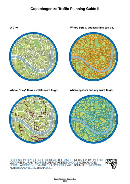
It's that time of year again, then the terrible ads saying how this guy is screwing us over comes over the airwaves and barrage telling us who to vote for. But unlike elections past, I don't own a TV. (Ahhhhh!) And like elections past, I really don't see anybody out there supporting a more bicycle future. We don't live in Austin, we don't live in Oregon, where the people and the people running for office are actually running on a platform of more transit, more bicycles, more pedestrians and less cars. No, in San Antonio, it's just another useless election voting for the same people for the same policies and all of them at some level or another saying that they're against Toll Roads.
Currently 83 miles up I-35, Austin is having their city council election right now. Bikeaustin.org is currently asking people to pledge to vote for bicycle and Pedestrians friendly candidates. Judging from what I've been hearing lately there, the City council regularly votes 11-0 or 10-1 on bicycle and pedestrian infrastructure and laws. Meanwhile in San Antonio, S Flores is back to the speeding stroad it use to be.
25-1
Closer to home, District 2 elections are taking place right now to fill the spot that Ivy Taylor left as she took the reigns of mayor. I spoken to all the candidates except one (Keith Toney) and asked them all if they would have voted for the removal of the S Flores Bicycle lanes. All of them replied back to me as, "that was dumb" to "hell no." I didn't ask this to Keith Toney and the reason why I didn't ask him is because he currently the Council Member for district 2 voted by the city council. Because of this, I wanted to ask him if he knew of any thing about what I heard about the city giving bicycle racks to the council members a year ago or two. He replied back saying he knew nothing of it. I also asked him about putting bicycle lanes down Hackberry and told him that one of the reasons why they didn't get put down was because of the Churches along the way wanted to be able to park. I send him an image (Image 25-1) that is above of a sign allow people to park in the bicycle lane during church hours and he ask me if this was okay and replied that this was okay. So if any of you are registered to vote in District 2, I really have know answer for you on who to vote for here, but all we can hope for is that these candidates don't repeat history.
At the end of the ballot, you'll come across State Proposition 1, a vote to move money recently received by the oil and Gas industry fracking their way in the Eagle Ford Shale and use that revenue to build and maintain roads. TXDOT recently held hearing on removing dedicated funding for bicycle and pedestrian infrastructure. Because of this, it is most likely I will not be voting for this prop. Then again if I don't vote yes, chances are, that money will be gone entirely so damn if you do, damn if you don't.
Personally for me, I really don't see any local candidate that would push for the necessary change of rules that need to be changed for better infrastructure, but instead just make useless plans, plans that will not be followed and just collect dust. I really have nothing to say about who to vote for except for the governors race. Gregg Abbott is in a wheelchair and I personally don't trust anybody in a wheelchair that opposes great sidewalks or rules like the Safe Passing Bill.
Images: 25-1: Somewhere on the Eastside of Austin, there's this sign allowing church goers to park in the bike lane during church hours. If someone has the location of this sign, please tell me.
At the last BMAC Bike Night meeting on October 6, I learned about several projects that wish to get priority funding like connecting the South and North Salado Creek Trails together through Fort Sam, the connections of the San Antonio Mission Reach to the Media River Trail, Via's sidewalk projects for bus stops and this one in particular caught my attention which was a Cycletrack down Floyd Curl Dr in the Medical Center which is #2 on the list. (Image 24-1)
24-1
http://www.alamoareampo.org/TAP/index.html
Out of all the projects, this one is the most expensive and for one I can say, yes, it is needed down a Stroad like Floyd Curl Dr. From what was explained to me, It would either by a one or two way protected bicycle lane like the ones you see in the Netherlands (Video below) from Huebner to Louis Pasteur. It the most expensive of all the projects which states it at $5.8 million. And it's located in a place that I feel for certain will embrace the path built. But here's my problem? Why isn't it on Huebner, Babcock, Medical Dr, Wurzbach or Fredericksburg Rd?
It's a good question after all Huebner is a 7 lane stroad with cars that constantly speed above 50 mph; why isn't there a plan to put one there. The Same with Babcock, a 7 lane stroad, but this one is sorta special, it goes towards town, it has an HEB, Via's Medical Center Transit Center and residential neighborhoods along it. But no, it's going here on Floyd Curl out of the way every ones way serving only about 3 or 4 hospitals and doctor offices that for the most part, the patients of these places are incapable of riding a bicycle.
It's the same thing I wrote about in June 11 posting "San Antonio Don't Deserve Bronze," for what I stated is that for the most part, City of San Antonio considers cycling a recreational activity and fail understand that bicycling can serve everyday people shopping, paying bills, working, connecting people homes to their jobs and businesses that they go to. When the protected bicycle lane along Floyd Curl is build, you'll still be more likely to drive your car to the HEB on Babcock, then to go there by bicycle, as is you'll still be more likely to drive to the restaurants along Fredericksburg or Wurzbach. What it will connect is a park at the corner of Sid Katz Dr to the hospitals along Floyd Curl.
I want to see stuff like this happening in San Antonio, but here's my beef, I want it down the stroads that are needing protection first, that connect everyday people with the ability to choose a bicycle over a car in going to the grocery stores, restaurants and other businesses along the way. Putting bicycle infrastructure down side streets and not the main stroads sorta reminds me of separate water fountains that we learn about in school that were around for Jim Crow because lets face it, you're pretty much considered a second class citizen when you are force to live without a car in San Antonio. Lets face it, I'm not the only one noticing the bias towards automobiles when it comes to transportation improvements.
So when I filled this MPO Pick your projects online survey, (Image 24-1) I picked three projects that I believe that is beneficial to the future of San Antonio and yes, I have every right to be criticized for picking a project that for the most part is recreational. They are the Salado Creek connection through Fort Sam (#3), a path I've constantly used after dark breaking the law using the trail for commutting. The other project is Via's MyLink Pedestrian Transit Plan, to build sidewalks on Fredericksburg, US 281 and Roosevelt for the purpose of providing some type of ADA accessibility between the bus stop and the near by businesses (#10). I also picked the Safe Routes to Schools: School and Transit Pedestrian Infruxtructure Improvements (#4) I hope that as they build these projects, they'll consider installing protected bicycle infrastructure along, but chances are, it ain't going to happen because cars are simply more important than a person choosing to help create an Ozone action day.
I want to encourage everyone to visit this website and pick your own projects (Image 24-1) and you'll have to make sure that all the projects you pick are under $11 million dollars. Everyone has until October 24, 5PM to do this online survey, so please get to it.
I have other issues such as #7 McCullough Corridor Improvements in which they're not providing any bicycle lanes along the project. After all, that space is needed for cars to make a faster left turn and not a protection of a human being on a bicycle keeping the air clean. Hope the other projects I pick do the same thing.
A few years ago, I designed a map on where you should live in San Antonio if you want to live without a car and this is what I came up with. (Image 23-1)
23-1
How I came up with the map.
Back in 2008, a friend of mine asked to be a sub director of a group on meetup.com because I knew of a lot of independent place on the south side. While a member of this group, someone told me that the to some people, they consider everything south of Hildebrand the South side. Personally I considered this in insult, but no matter, it gave me more independent places to choose from. As I met more people from the far north side, it became more evident on the disconnect I personally had. There was this one vegan lady who drove a smart car, and a big supporter of PETA. She claimed that she was being an environmentalist by not eating meat, and driving a "smart car, but she lived over the "Environmental sensitiveness" Edwards Aquifer Recharge zone not realizing that her dog poop was ending up in our drinking water. It's funny, I don't live over the recharge zone or produce any greenhouse gas while riding my bicycle, but she does through her internal combustion engine. This made me realize that you should be living inside the loop (Loop 410) if you wanted to live without a car. My short experience with her and her companions made me realize that there was a lack of culture that San Antonio is famous for out side loop 410
The more I thought about it, loop 410 was pretty large, and even then before I reached the loop, I got harassed more and more on my bicycle, like telling me to get on a non existent sidewalk or even better, telling me what I was doing was illegal for which if they ever read their drivers manual issued by DPS, it will tell you , I'm pretty much a car under the law. During that time I came to the realization that if you happen to live in a grid street area, your more able to find an alternative safer route to ride your bicycle on. It was around this time, that I realized where I got on the bus, and where I got off the bus to ride my bicycle, and then it became clear. I would first choose a bus when I was south of Southcross, or north of Hildebrand before I decided to get on my bicycle and ride it. By early 2010, the map came together after I realized that with in the drawn area, you can find more than one bus to get to downtown on, and thus, it formed into what you see today. It was then I realized that if you live south of Hildebrand, north of Southcross, east of Cupples, and west of Walters, you could comfortably live without a car in San Antonio.
Exception on the map:
Now there are some areas that are inside my little square that I really don't recommend living in like River Road, Roosevelt and Southcross area, and the neighborhood between Hackberry and I-37. Outside my little map, Government Hill, South San, and Mahncke Park just to name a few.
River Road by default of TxDOT and USDOT, decided to cut off a beautiful neighborhood with the building of US 281. It's pretty much a gated suburban community and although it is close to downtown, I don't recommend it because the Albertsons grocery store has been replaced with a YMCA and during any given day, your nearest bus stop is either on St Mary's or Broadway.
Again, this area of Southcross Blvd and Roosevelt Ave is an area where even though industry is nearby, there a lack of safe bicycle facilities and even though the Mission Reach is in this area, I don't include it because much of it is in a flood zone.
Mahncke Park and Government Hill is also an area I recommend that you avoid simply because that if your unable to find a place close to Broadway, you'll be leaning to owning a car sooner rather than later. This is due to much of the area being without frequent bus service. Although parts of Government Hill East of N Pine is has the 20 serving it, I took it off of the area simply because the 20 is more of a cross town bus than a downtown bus and downtown buses go to the places where you can connect with the most buses.
Relations to Bicycle Culture.
23-2
If your ever on your bicycle, you'll notice more bicyclist with in my square rather than outside of it and even better, more Frankenbikes inside my square than outside my map. Yet there's virtually no bike lane to speak of. Now that's "sort of" changing of course, but so far what I'm seeing is trying to avoid the inevitable of putting down where they are needed the most and most of all, taking out a vehicle lane for a protected bicycle lane also known as a cycletrack. And what I'm seeing get put in lacks certain paint and signage to make it work.
After talking with a naysayer of the S Flores bike lane and reading a story on little plastic thing that Starbucks gives out to some customers who are driving made me realize, we're focusing on the wrong places to put down bicycle lanes and Cycletracks. Yes, they're needed at those places, but lets face it, if they're put in and around the Downtown area, they'll serve more of a use than ever being put on Culebra outside loop 410 or even worse, down a street that don't need it. Since the city of San Antonio isn't serious about bicycling, but about driving, enjoy getting stuck behind a stinking car. (Image 23-2) It does make me wonder if there's an element high up with in the local political pyramid that don't want a role for the bicycle other than recreation.
Images: 23-1: My map of where you should live without a car. If you want to make one of your own, I recommend that you use yahoo maps instead of Google. Make sure you put down that these are walking directions and they are...http://yhoo.it/1F7QFuy
Hildebrand at Broadway Club Dr at Wilson Blvd Cupples Rd at Brady Blvd
Brady Blvd at S Zarzamora S Zarzamora at W Southcross E Southcross at Gevers St Gevers St at Walters Walters at Sherman St Sherman St at N Pine N Pine at Josephine Josephine at N Alamo N Alamo at Broadway Broadway at Hildebrand.
23-2: A Family stuck behind traffic on Houston St at Presa looking East back in October 2012.
As I continue to write this blog, I constantly show how the City of San Antonio and it's political leaders aren't interested in providing anything in the way of transportation improvements unless it has at least 4 wheels, an internal combustion engine and helps keeps the myth going that global warming is a conspiracy.
Back in April, I wrote the post Useless Bicycle lane, showing how three bicycle lanes in the city are completely useless in providing actual protection. They were S Main Ave, S Pine St, and Elmendorf St on the west side. Since my publishing of that story several things have changed and I can add two new ones to that list which are Village Parkway on the Far West Side, and Diana on the East Side.
I think a lot of you are asking what constitutes a Useless bicycle lane, and this is how I come to figure out that conclusion. The first thing I go by the Dutch principal which you can see below this paragraph in this video explaining when and where you put one and a quote of Jeremy of the Critical transit blog Transit Tip #14 which states: "There’s a tendency among bike advocates to champion the delineation of a
“bike space” even without any actual space being created. You know, “if
there’s room for a bike lane” without changing anything else on the
street". When the Dutch put down a bicycle lane (and they do just like us Americans) or a cycletrack, they put them where they are needed, like places where cars go faster than 30 KM per hour. For us Americans, that roughly 20 Miles per hour. There's a reason why nearly all school zones are 20 miles per hour, because that is the safest, fastest speed possible to prevent collisions and reduce harm when collisions occur. The Dutch put those 20 mph zone not just in school zones, but down residential streets. You also see 25 MPH in the neighborhoods of Terrell Hills and Alamo Heights, which makes me think they sort of get it.
The Improvements
22-2
Back in July, S Main Ave (Image 22-2) got a new paint job, and this time taking into account of the parking occurring on the street. Before, they had a bicycle lane with parked cars, (Image 22-1) now there's a bicycle lane, a parking lane, and smaller drive lanes. It's not perfect, but it's better than the last time. I call these type of lanes, Double Edge Swords for you have a space to ride, but when a parked car and a vehicle is passing you, you have no escape route. So if your ever riding down S Main or any other street with this type of paint job, simply ride in the parking lane when there are no parked cars and treat it like a buffered bicycle lane that is currently popping up all over Austin. Take it from me, you'll feel better in doing so, and safer.
Elemndorf out by Woodlawn Lake also got a small improvement, that of a 25 MPH sign and as I was riding down it, I notice that most of the cars were following it too. The bicycle lane with parked cars in it is still there, but the wasted paint it's fading day by day.
New Useless Lanes
22-3
Village Parkway on the far west side off of Culebra Rd is one of these useless bicycle lanes. (Image 22-3) With cars not just parked in it, but it is down a residential street where cars should be traveling at 20 mph instead of the 30 mph posted. To add a touch of stupidity to this useless lane, the neckdown at the corner of Cross Springs and Village Parkway (Image 22-4) was poorly built. You would think that if the city of San Antonio is going to build a traffic calming device, they would do it right in the first place and actually calm (slow) cars, but no, they did not. You see the ideal of having these neckdowns is to slow vehicles while making right turns.
22-4
Now I wouldn't be complaining about the neckdown along with the bicycle lane, (Image 22-4) but since they build it with rainwater runoff being more important than having adequate protection of the cyclist. Common sense should have told the idiot who designed it that cyclist and cars don't mix and should have had a 5ft opening through the neckdown. Or better yet, realize that the bicycle lane is useless in the first place and build the neckdown out to the place where you see the outer stripe of the bike lane, but no, they had to reroute the bike lane around it bring it into close contact with impatient drivers. The good news about all of this is the bicycle lane on Culebra and although I think removing the right traffic lane and putting down a protected cycletrack would be better, it's better than nothing.
22-5
Diana on the East side has one of these useless bicycle lanes. (Image 22-5) It's a very wide street and does nothing for safety of the pedestrians or cyclist. It does however provide a small space for people walking along the east side of the street because the city felt that not having a sidewalk would help people not fall into the ditch that runs along side Diana. There's barely enough traffic along this street to really warrant the width of the street or the bicycle lane there except when the school is ending or starting the day. This bicycle lane doesn't need to be on Diana, but should have been placed on Rigsby where the fast moving traffic on that stroad should have a least a bicycle lane or better yet, a protected cycletrack.
The solutions that I come up are something that the city cannot do because that would slow down cars, and we just can't do that. One of these solutions is changing the law that forces the CMI people to use AASHTO standards which are great for long distance interstates instead of the NATCO (National Association of City Transportation Officials) standards that were developed for urban areas and looking in there to determine how wide the street needs to be because this road surface needs to be narrowed with wide sidewalks along both sides with planted Pecan trees between the sidewalk and the street. This would do wonders for the property values and provide shade along the street along with 25 mile per hour signs would also do good. Maybe a parking lane along the elementary school and the city park would also be good instead of a useless bicycle lane.
Now there are others that I've been considering to be useless such as SW 19th St, Timberhill, Rittiman, and even Semlinger Rd, but I'm not yet to declare these useless because traffic volume is just enough to consider their need, but what's the point, after all people consider this space to better use by parked cars than a space for a cyclist to be. Keep San Antonio Lame.
Images:
22-1: A picture of S Main Ave looking north back in April, 2014
22-2: A picture of S Main Ave looking north back in August, 2014
22-3: A picture of Village Parkway looking west
22-4: A picture of the neckdown at Cross Springs and Village parkway looking east.
22-5: A picture of Diana looking north.
Every two years, Bicycling Magazine creates this list of the 50 top bicycle friendly cities in America published in Oct 2014. We're down to #48 (Image 21-1) from #47 back in July 2012 (Image 21-2). 83 Miles north of us, is the Weird city of Austin, and they're also on the list at #11 from #13 back in 2012 (Image 21-3). Another blogger recently wrote about this in Fit In S.A. saying quote: "The completion of the Mission Reach is one of the reasons San Antonio made it onto the list." That's the only reason why we're even on the list folks because of a "recreational trail" and with B-cycle serving it.
21-2
Don't get me wrong I love the Mission trail, but unlike back in 2012, Bicycling Magazine also mentioned the bicycling community quote: "An emerging cycling-friendly vibe fueled by 1,700 miles bike network of lanes, paths, and sharrows." What the hell happened, oh, that's right, the City council voted for the removal of such a system with only one member, Shirley Gonzales voting to keep it. Also happened was that Boneshakers got it's property cut off by the San Antonio River Authority, and they went out of business at their river location and their Hays Street Bridge location. Cars still park in the cities only cycletrack on Avenue A, and to top it all off, the city don't give a damn about cars parked in your bicycle lane.
21-3
But I don't think it is because of our expanding B-cycle or a completed recreational trail that we made the list, in my own opinion I believe it is the fact that San Antonio has a rich bicycle culture. It is you the people who come out to Frankenbike, Downtown Highlife Bicycle Club Ride , the Zombie ride, and all the other rides in San Antonio. It's bicycle groups like The Wild Dawgs, the Street Ratz and many many more. It's those who get on their bicycle or as I like to say "put the fun between your legs," and ride everywhere just because. You see it every First Friday with people just riding down S Alamo and going to the bicycling friendly places like Alamo Street Eats, and other bicycle friendly places like the Bottom Bracket Social Club.
Recently, Several Stroads where recently repaved in District 1 near downtown. Here on Colorado St, they finish repaving it and repainting it (Image 21-6). According to the Bicycle Master Plan, Colorado St from I-10 to Caesar Chavez (Image 21-5) has a plan for a road diet similar to what was done to S Flores. But as you can see in my recent photo of the place it has the same configuration that makes a stroad a stroad. Hey Mr Bernal, where's the bike lane that you promised? (Image 21-4)
21-5
21-6
But lets face the reality here, San Antonio is too stuck behind the wheel of a car to ever envision a Netherlands network of bike paths and Cycletracks or ever have light rail transit. Although the city is constructing a cycletrack in front the Henry B Gonzales Convention Center along I-37, chances are it won't be used like the city ever intended because there's no signs, sharrows, or painted green like you would see on a similar path in Austin (Image 21-7). If things don't start changing, we will not be on the Bicycle Magazine list come 2016 while I'm betting that Austin will be comfortably in one of those top ten positions because they're committed to building more bus stop islands like this one on Guadalupe St (Image 21-7). Keep Austin Weird, Keep San Antonio Lame.
21-7
Images:
21-1: A picture of the Bicycle Magazine October 2014 rating of San Antonio, TX as #48 of one the top 50 Bicycle Friendly Cities in the USA.
21-2: A picture of the Bicycle Magazine July 2012 rating of San Antonio, TX as #47 of one the top 50 Bicycle Friendly Cities in the USA.
21-3: A picture of the Bicycle Magazine October 2014 rating of Austin, TX as #11 of one the top 50 Bicycle Friendly Cities in the USA.
21-4: A Screenshot of my Facebook Re-posting of Diego Bernal's FB posting of how San Antonio has 1,700 miles of bile lanes planned and my friends response to his comment.
21-5: A Screenshot of page 28 of the Bicycle Network PDF of the Bicycle Master Plan.
21-6: Colorado St Looking North one block north of Martin St.
21-7: The Bus Stop Island on the Guadalupe St Cycletrack in Austin, TX.
When a Council person or any other similar politician complains about the state of transportation in San Antonio, I wonder why they aren't walking, taking the bus or riding a bicycle for if anybody did any of that, then their complaints would have merit. But no, they complain about how there's too much traffic and we need a Comprehensive Transportation Plan on the books to fix it. I've been hearing about this for over 10 years and during that time, I've seen very little improvements in the area of a "comprehensive transportation system" for San Antonio.
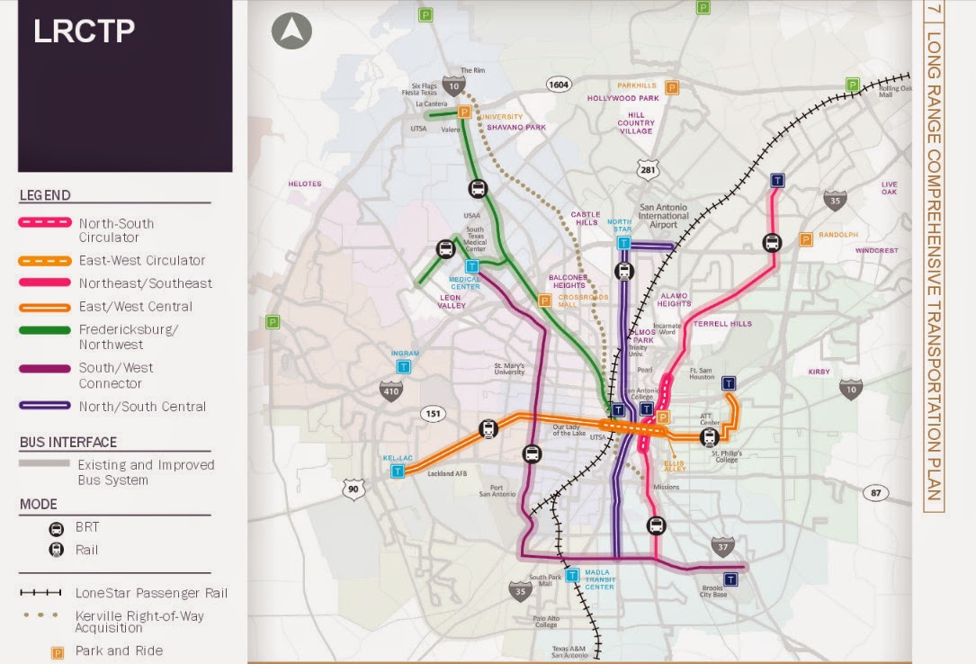
On Sept 12, mysanantonio.com published an opinion from District 8 Councilman, Ron Nirenberg titled "Times Have Changed; So Should Transportation." In his opinion piece, he highlights the problems in transportation that we all know about, lack of funding, how there's no rail, and how we need a "Comprehensive Transportation Plan" to fix the problem. Um here's the thing Mr Nirenberg, we have a comprehensive transportation plans already, just go to the Alamo Area Planning Organization, or look up the City's own Bicycle Master Plan. Governments are full of plans on the books. A good example is the Austin/San Antonio Commuter Rail has been on the books since 1998 and I believe that a hard copy of this plan sits at the Central Library downtown at 600 Soledad collecting dust. Via also has their long range transit plan on their website aptly named "Long Range Comprehensive Transit Plan."
Ron Nirenberg highlighted the problem with transportation in his opinion quote:
"Rail relocation, which would make those routes safer, faster and less
congested, has been proposed, but it thus far has not gained enough
political or financial momentum."
Not enough political or financial momentum is the problem that he's sites as the reason why we're stuck in traffic or at least in the context of this quote, of having hazardous material on freight trains traveling through the central part of the city. Well he's only half right because he, like the rest of the City of San Antonio and the entire state of Texas for that matter cannot comprehend the ideal of not needing a car to get around. Think about this concept of not needing a car for a minute, because when you go from point 'A' to point 'B' in San Antonio, you get there by driving a car, so how can we have "Comprehensive Transportation System" in place when the average person can't realize the alternatives because the only alternative that they can think of involves driving a car going from point 'A' to point 'B'. There is no walking, there is no taking the Via Bus, there is no riding a bicycle, there is just the car traveling on the clogged stroads to get there.
The reason why the Representative for District 8 and the people he represents cannot understand the basis for a "comprehensive transportation system" which is using the two feet that god gave them is because they live in a place where the places, from home to the grocery store and to work are separated by extreme distances that make walking impractical. This is because as they were building houses and retail outlets in this part of town, they never took time and thought how one could walk from their house to the grocery store or bicycle between those places safely. At the time gasoline was cheap and this was the American Dream. District 8 is a great example of the failure of suburban sprawl exemplifying how it makes sure everyone who lives out there, has to own a car to get around and because gasoline is now staying roughly at $3 a gallon, the money that is needed to keep the car up and running doesn't stay in the community but leaves that community because the majority of those places that fuel and repair cars aren't local except for Valero. That money doesn't stay in the community except for the minimum wage clerk's paycheck. Over time, we'll continue to see less and less local tax revenue to pay for road repair. It gets even worse when you have parking minimums for business making it impossible for the average joe to start a business. Chuck Marohn, the host of the Strong Town podcast explains it better than I on why in the long run, the suburbs are doomed.
20-1
When you ask the average San Antonion on what they want in rail transit,
they'll say that they want a Subway, they want a Monorail. They want
these very expensive forms of rail because they don't want that rail take up space on
the ground that is used for cars. But this isn't what Via's 2000 light rail plan
had in mind that Mr Nirenberg mentions at as quote, "a large scale, regional commuter rail plan." As you look at the maps for the light rail, (Image 20-1) you'll see how it will most likely go down Commerce/Buena Vista east/west and north/south on Flores/San Pedro. The reason for this, unlike Dallas Light Rail which goes down old railroad tracks, we here in San Antonio lack such old railroad tracks, also known as right of way to put the light rail down. Personally, I don't believe we'll ever have rail transit or a
sufficient bicycle lane network because we're not willing to give up
that lane that we currently have for cars for those alternatives. If we're going to have a "comprehensive transportation system" in San Antonio, the basis of this blog, we need to start making political sacrifices to take spaces that cars use and turn them into sidewalks and protected bicycle lanes. Even the latest plan from Via still has some light rail, but not as much.(Image 20-2)
20-2
As time goes on, we'll have less and less of federal dollars to put to roads not because the political will for more car lanes isn't lacking, or as Mr Nirenburg says, "Conflicting political agendas have led to the diversion of funds that
should be spent on basic road construction and maintenance." Because we depend on these handout of the federal government to keep San Antonio moving, we're going to have less and in my opinion, no more chances of putting in rail either down the stroads by removing a car lane or above the traffic.
The reason why we have no "political momentum" for
rail, for sidewalks, for alternatives because everyone is driving. Your action confirmed that you, Ron Nirenberg has no political will for
"Comprehensive Transportation System" for you voted to remove that alternative,
comprehensive transportation infrastructure on S Flores. Even though I
wrote how we didn't need a streetcar to improve development on Broadway,
you sir made sure that Via's attempt to change the political momentum
to a more alternative, comprehensive transportation system was derailed even
before the first rail was laid.
To go forward Mr Nirenberg you and your peers need to understand that if you want that "Comprehensive Transportation System" as you stated in your mysanantonio.com opinion, you and your peers are going to have to make political sacrifices standing up for unpopular projects such as removing a drive lane for a protected bicycle lane and wider sidewalks. The rail transit you want is out of the picture at least for the next few years for the money that you need for that rail is not coming home. All you can afford now is what you voted against, bicycle lanes and more bus service. I understand better than anybody out there on why people won't use the bus, why they won't ride a bicycle but these are the only alternatives you have left for a "comprehensive transportation system." This is all we can afford to do now. We have plans on the books, but if we don't follow through with those plans, what's the point with having one?
Personally when I read your opinion piece, I yawned and thought how you, like
the rest of the city will always be complaining and whining because they're
stuck in traffic and maybe stuck in traffic because a cyclist like me
is taking the lane to safely share the road. Think about that next time Mr
Nirenberg when your stuck in traffic.
Speaking of comprehensive transportation plans, it's that time again when the MPO dust off the old 25 year long range plan and starts to make a new one. You can find out more at this web address. http://www.mobility2040.org/
Sorry for the wait, but as usual my life has been busy. Since I got a new job and my hours have change, I'll be changing the publishing day to Monday or Tuesday every week and I'm still committed to publishing every week.
Also, I'll be creating two new pages, one, of important meetings that cyclist or concern citizens should attend to make San Antonio a real place, and two, one of bicycling related events that are taking place in San Antonio. Streetcar Part III, No Need for Streetcars Down Broadway.
Now lets get one thing strait, I was a streetcar supporter. Why you ask, because even this slow, lousy system would be a plus to our transit system that sucks. It would have gotten some political supporters that "choice users" bring to the transit discussion that San Antonio currently lacks, and most of all, I wouldn't have to worry about a bike rack being full especially on a rainy day for I would be able to take my bicycle aboard and not just the minimum three allowed and most of all, maybe a chance to actually get a protected bike lane on Broadway. I also felt that this was a scheme in Via's long range plan from the former CEO, Keith Parker, now in charge of Atlanta, GA MARTA in which he said, that once you build it, the people are going to change their tune from the current "rail sucks" to "when are you going to bring it to my neighborhood." I felt that after they build it, they would have eventually either expanded the system to include more of the city like out to Loop 410 with faster speeds, or put light rail back on the ballot like back in 2000.
19-1
The more and more I heard about the development results of the streetcar, the more I felt that the goal of the Streetcar was based on the McKinney Ave Streetcar (Image 19-1, 19-2) in the Uptown neighborhood in Dallas which to me seems to be a place a lot like La Cantera. It was the dream of Mayor Hardberger to connect the Pearl with the rest of Downtown and the streetcar would have done that.
Back in September 2013, I went to Dallas to see the new transit service to the largest city that lacks transit service, Arlington, TX; although, what I found was disappointing, I also wanted to ride with the Dallas Critical Mass to get their opinion on how they deal with McKinney Ave Streetcar tracks for which they said they treat it like any other street with lots of pot holes.
19-2
19-3
That night as we rode, they took me to a place called the Truck Yard just off of Greenville Ave, and there I discovered a place that was the pinnacle of what good urbanism brings out, a First Friday every night, or at least every weekend. For those of you who don't know what First Friday is, well think of the Pearl Farmers Market is every Saturday morning. It was after that that I finally realize that we don't really need a streetcar to achieve development goal of what the Streetcar promised,(Image 19-3) but what we really need to do is create the foundation of a neighborhood that creates the conditions that makes a really happening place.
19-4
To create that foundation of development that was sought with the Streetcar, we need to fix the problem that is currently found on Broadway or for that matter, the entire downtown where the Streetcar was planned to travel down.
Before the big sidewalks were added, Greenville was much like Broadway is currently. A stroad with fast moving, many lanes of traffic and nothing happening along it. Today, Greenville Ave is a place is much like South Alamo but with super size sidewalks. Even though S Alamo lacks the big sidewalks, the concept is virtually the same, two lanes of slow moving traffic with sidewalks protected by plants or parked vehicles, and a community that is allowed to reinvent itself. Broadway is the opposite of that with fast moving cars, multiple lanes of traffic and tiny sidewalks with no protection from traffic full of obstacles like this bus stop at Fourth and Broadway.(Image 19-4) It's a Stroad in every sense, every space for cars, not much for anything else. We also need to fix the zoning when it comes to new development and make it more flexible, such as no parking minimums with new development.
19-5
19-6
You can tell just by looking at the area around Greenville Ave that it's a happening place and not just by the dancing frogs on top of the Taco Cabana.(Image 19-5) The sidewalks that are here use to be vehicle lanes (Image 19-6) and because there's a space for parking the cars along the street, it provides that barrier between the moving vehicle traffic and the pedestrian activity. Here's my 6 minute video of the place across the street from the Trader Joes. In this video you'll see what is making Greenville Ave a great place and what is missing from Broadway, Slow moving Traffic and good sidewalks.
19-7
For this purpose, I'm only going to focus on Broadway and not other stroads that the Streetcar would have went down. Now the Streetcar was planning to go as far north as Josephine St, but for our purposes, we can actually include the part of Broadway as far north as Hildebrand due to the fact that my fixes won't cost $270 million and the fact that the stroad scape is the same. I've divided Broadway into three parts, (Image 19-7) the first part is the Broadway that has 7 lanes, 6 travel and one center turn lane is the Midtown Section. The part goes underneath the freeway I call the 281 section, and finally, the Downtown Section from Jones to Martin, where we have useless sharrows, narrow sidewalks and to the rest of the general public, abandon buildings. (Image 19-22)
Also for the examples, I'll be using cross sections illustrations like the one below which is how Broadway is pretty much designed today.(Image 19-8) All cross sections illustrations will face north and all lanes have been measured by me on the actual stroad in this case, Broadway. Through these cross section illustrations, I'll be demonstrating the possibilities for Broadway and use this same form for other stroads in future posts. In this cross section illustration(Image 19-8) you see the term "bus lane." For our purposes, this is a regular drive lane where you're most likely to see the bus traveling in.
Midtown Section
19-8
The Midtown section starts from Hildebrand Rd and goes to Casa Blanca. I written about this section before in other blogs such as Two accidents that didn't need to happen, and #sasidewalkssuck. Here you have 1 center turn lane, and 6 drive lanes. Much of the 5ft sidewalks in this section live up to the hashtag #sasidewalkssuck. The Streetcar would have made the sidewalks wider along this part of Broadway, at least to Josephine, and perhaps added some parking in what is now that right 10ft lane. To improve Broadway, the cheapest thing we could do to improve this stroad is to turn that right 10ft drive lane into a buffered bike lane or a protected bike lane by poles. (Image 19-9) By doing this we make it feel a little safer to walk and bicycle along by removing the fast moving traffic that is now next to the sidewalk.
19-9
The Problem with this design comes when we get to the bus stop. You see, currently if a Via bus wishes to stop along Broadway with the Cheapest concept in place, it will have to invade the buffered bike lane. So lets add a small bus stop island (Image 19-10) so the cyclist can keep cycling and the bus can stop without having to worry about running over a cyclist.
19-10
But lets face it, if we are to really improve Broadway, the way the streetcar would have done, we're going to have to remove that center turn lane and put down some on street parking. Here (Image 19-11) is what the city should be proposing to this part of Broadway. I call this the "Ideally Concept" where I reduce the number of drive lanes from Current (Image 19-8) six lanes to four lanes. I remove the center turn lane and put that space for parking on the west side of Broadway and made the sidewalks bigger. Now remember, your always looking north on my cross sections illustrations and the reason why I put the parking on the west side, (the Witte Museum side) is because that's the side on which you'll find Brackenridge Park and businesses without on street parking for the most part. I did my measurements for the Midtown Section in front of the Tuk Tuk Taproom,
so all measurements are to that area, however, the Right Of Way,
that's the Government property part of Broadway, gets a little bit bigger
as you go further north so these things could be widen a bit.
19-11
Now to put in the bus stops with the "Ideally Concept," I put in two different versions. On the west side of Broadway, we remove the parking lane and put in a bus stop island with Shelter. (Image 19-12) For the east side, since the bus stops aren't as big like the current bus stop at Lions Field park, I've decided to go with the bus stop island being about 4ft wide.(Image 19-13) This way, no matter what side your on, you'll always have a protected bike lane without having to worry about a bus making a stop in the bike lane.
19-12
19-13
Now Traffic flow is important for this Stroad is a major thoroughfare. But we need less of the stroad and more of a famed Boulevard (BLVD) design. So reducing the number of driving lanes from six to four, we reduces the current scene of cars trying to out run each other. By reducing the travel lanes from 6 to 4 and removing the center turn lane, we also reduce the amount of distance a person on foot has to cover when they do cross Broadway from 74ft (Image 19-8) to 44ft (Image 19-12). And with the protected bike lanes, we create a safe place for both person on foot and on bike.
281 Section
19-14
This section as indicated in Image 19-7, is between Casa Blanca and Jones. It's also the section underneath the interchange of I-37/US 281and I-35. In this section, (Image 19-14) you currently have a 5ft bike lane, four 11ft drive lanes and one 10ft center turn lane. Not much improvement needs to be done to this section, for the 5ft bicycle lanes does provide some type of barrier between the traffic and the sidewalk. We could use some wider sidewalks, but as a cyclist, I don't want to give up on my bike lanes. So to do this, we need to remove that 10ft center turn lane and put that 10 ft to the sidewalks and a barrier to make a protected bike lane. We can also put in some Bus Stop Islands with out having to reduce the driving lane width and not having to reduce the walkability.
19-15
19-16
Now We've done our improvements to this Section to the street scape, we now have to figure out how to use all this green space underneath the bridges. Has anyone ever thought as this space as a city park? Up until about mid August 2014, there was a small pond that formed underneath one of the bridges (Images 19-17, 19-18) and across the stroad, you'll see a dog park (Image 19-16). Here's my question, why can't we have a bigger dog park that takes advantage of the shade that this exit ramp from I-35N to I-37S bridge produces? And this rain water created pond, back in June and July, I saw several species of birds including a pair of Black Belly Whistling ducks with a family of duckings as well as a Green Heron gorging on tadpoles, and other bug aquatic life. (Image 19-17). Currently the pond has dried up, but given another big rainstorm, it will be back.
19-17
19-18
19-19
City Parks and open space for that matter has been known for years helps with making people happier and healthier. It's that touch of nature that makes city living better. When we lack green spaces in the form of city parks, gardens and trails, we make our communities just a little bit of a dimmer place to be in and take it from me, San Antonio lacks a lot of parks for people to play and relax in.
Downtown Section
19-20
19-21
This is where the Streetcar would have served the entire section. It is also the section where even though we are pretty much in downtown, we have a bunch of abandoned buildings, or at lest to the general public, they are abandoned.(Image 19-21) It's also the section where we would have seen most of the development that the streetcar promised to delivered.(Image 19-3) But look at what is wrong with it right now, you have an abandoned street scape with narrow sidewalks, useless sharrows (Image 19-22) with places that nobody goes to unless they work there. It's pretty much a dump even though it's like two blocks from the Riverwalk Museum Reach. Now the cheapest thing we could do to improve this section of Broadway is to remove that god awful 16ft lane with the useless sharrow/parking lane (Image 19-20) and bring back the bicycle lane, but that would make it somewhat safer for us cyclist, but that's it. (Image 19-23) And this stretch of Broadway use to have bike lanes, but somebody thought that parking was more valuable, but go there on any day of the week, and tell me, who in the hell is parking on Broadway because for the most part, I barely see two vehicles, maybe three. If Spock from Star Trek said that "the needs of the many, outweigh the needs, of the few," wouldn't a painted bike lanes serve more people instead of just three or four individuals with parking spaces for a car?
19-22
Now I don't know what the street scape was going to look like with a streetcar, but my general feeling it would have looked something like this, with improved wider sidewalks.(Image 19-23)
19-23
Now we just don't need Improved sidewalks, we also need a zoning ordinances that will encourage the type of development that the streetcar would have brought, but before we play with the zoning ordinances, we need to make it a more comfortable place to be walking.
19-24
We have 76ft to play with, and we could do a whole bunch of designs, but this is where I cannot decide what is the best choice for the Downtown Section of Broadway. So the question should be asked, do you want Broadway to have flowing traffic, or do you want it to be like Greenville Ave in Dallas? You have to remember, Broadway is one of those important corridors for the city for it is sandwich between a freeway, and a military base. Now in all of my Cross Sections, I have a protected bicycle lane and that's simply because protected bike lanes bring out cyclist and reduce injury risk by 90% and from my experience of riding the one in Austin on Guadalupe St, it's way nicer than riding in traffic with useless sharrows.
The reason why they took out those bike lane in the first place back in 2011, was because there was no on street parking. Well if parking is really that necessary, then this is how The Downtown Section of Broadway should be designed. It should be designed with a Center Turn lane, two drive lanes and two parking lanes on both sides, but this design keeps the sidewalks living up to the hashtag #sasidewalkssuck.
19-25
Now here's the question, do we need parking for both sides of Broadway? If we do, then the concept you see above (Image 19-25) is what we're going to get, but if we want wider sidewalks and keep the traffic flowing, we're going to need to keep the center turn lane, and we're going to need to remove a parking lane from one side of the street. The question is, which side should that be on? For my suggestion, lets put it on the east side of Broadway and add that space that we've taken away from the parking, to the bike lanes and sidewalks. And because we've added space to the sidewalks, lets plant some trees which are lacking right now on this part of Broadway.(Image 19-26)
19-26
For the Bus stops, let's add the 4 ft bus stop islands on either side, only this time when we put it on the east side, we put the bus parking place where the parking lane is. On the West side, I simply added a bus stop island allowing for vehicles to pass in the center turn lane like they do currently on S Flores where the city council voted to remove the lanes.(Image 19-27) We don't want to switch the traffic lanes from one side to the other block by block for that would create some confusion on where to drive and it will create some bad politics that we've experience like before with S Flores.
19-27
I've just showed you how we could improve Broadway with simply changes the way we lay out the street design for Broadway. Now remember, this isn't enough, we also have to change the zoning ordinances so we can allow the development to come from the ground up and we also have to leave room for traffic flow. This is possible, but as long as we have an unwillingness to allow transformation, slowing down vehicle speeds, and putting people on foot and bicycles first over personal motor vehicles, we'll never see a great place that could be Broadway.
Images
19-1: McKinney Ave Streetcar Stop in front of the Starbucks at 3699 McKinney Ave looking Southeast
19-2: McKinney Ave Streetcar Cityplace Station looking west.
19-3: Via Metropolitan Transit Streetcar advertisement claiming about the streetcar developments it would have brought to Downtown. 19-4: Via Metropolitan Transit Bus Stop at the corner of Broadway and Fourth looking north.
19-5: The Taco Cabana at 1827 Greenville Ave, Dallas Texas looking South
19-6: The View of the large Sidewalks on Greenville Ave at Prospect Ave looking south.
19-7: Google Satellite View of Broadway with illustrations showing the different sections of Broadway.
19-8: Cross Section Illustration viewing North on Broadway that is between Casa Blanca and Hildebrand
19-9: Cross Section Illustration viewing North on Broadway having the right drive lane turned into a buffered bicycle lane (Right) or a protected bike lane (Left) 19-10: Cross Section Illustration viewing North on Broadway with a bus stop island being placed over the Buffered Bicycle lane. 19-11: Cross Section Illustration Viewing North on Broadway. The Ideally Concept with 4 lanes of traffic, 1 parking lane, two 6ft protected bicycle lane and 7 1/2 ft of sidewalks on either side. 19-12: Cross Section Illustration Viewing North on Broadway. The Ideally Concept with the Bus stop island on the west side of Broadway.
19-13: Cross Section Illustration Viewing North on Broadway. The Ideally Concept with the bus stop on the East Side of Broadway.
19-14: Cross Section Illustration Viewing North on Broadway that is between Casa Blanca and Jones.
19-15: Cross Section Illustration Viewing North on Broadway. The Ideally Concept with Protected bicycle lanes and bus stop islands.
19-16: The Dog Park at the corner of Broadway and Roy Smith St looking Northwest.
19-17: The Pond During July underneath the bridge with a family of Black Bellied Whistling Ducks and a Green Heron. Viewed from Broadway eastward. 19-18: The Pond At around August 10, 2014. Viewed from Broadway eastward.
19-19: 3 Cyclist riding southbound in the bike lane on Broadway underneath 281 looking North.
19-20: Cross Section Illustration Viewing North on Broadway between Martin St and Jones.
19-21: Picture of one of the buildings that looks abandoned at the corner of 6th and Broadway looking West.
19-22: Picture of one of the Sharrows on Broadway in front of the DPT parking garage viewing North
19-23: Cross Section Illustration Viewing North on Broadway between Martin and Jones. My ideal concept on how Broadway would have looked if it added Modern Rail Streetcars.
19-24: A map of San Antonio illustrating how because of Fort Sam Houston and US 281, how Broadway is a "funnel" for traffic into downtown.
19-25: Cross Section Illustration Viewing North on Broadway Between Martin and Jones on how it would look if they removed the 16 ft right lane and turn it into a parking lane with a protected bicycle lane.
19-26: Cross Section Illustration Viewing North on Broadway Between Martin and Jones on the "Ideally Concept" would look like
19-27: Cross Section Illustration Viewing North on Broadway Between Marin and Jones on the "Ideally Concept" would look like with bus stops islands at either side of Broadway.