Author of Blog: Daniel Day

Sunday, January 25, 2015

Everything Wrong with The Convention Center Cycletrack

Happy new year to everyone. As usual life gets in my way of writing, but I have settled on at least one story ever two weeks. Also as I finish writing this post, I would like to inform all of my readers of the lost to the local cycling community and a friend Matthew Ahern. He recently past away on Thursday due to a bad heart. He didn't so much helped to make the bicycling community as he worked to try to make San Antonio Real. I fell out of touch with him when he lost that house on Howard St in which he wanted to have as a urban farm.  San Antonio will miss you.

Also to keep this blog from being published, I got sick to the point that this screen was very hard to see and I was unable to walk around.  Bright screens hurt my eyes and since I've just recovered, It just now coming out.
31-1

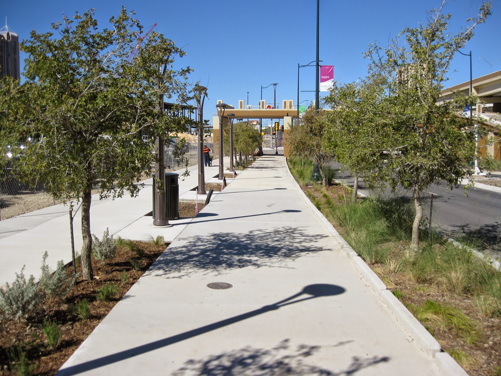
 Hey San Antonio, have you ever wanted a bicycle path like you heard about them having in Denmark or the Netherlands? Or what about the ones their building in Austin? Well have there is one right now along the frontage road of I-37 in front of the Convention Center.(Image 31-1).
31-2

I notice the new cycletrack when I first saw the cut out in the concrete at the intersection of E Commerce and the southbound exit of I-37 back in 2013. (Image 31-2)  I normally see these cuts in sidewalks underneath freeway bridges for storm water drainage, but it's rare to see these things downtown and so big for that matter.  Now I was hoping that they would at least spread it out down E Commerce, but knowing the unofficial stance towards cycling, I knew it wouldn't happen.  I also knew that from the get go in 2013, that Transportation & Capital Improvements would have all the signals screwed up and bias towards everyone not in a car. Now don't get me wrong building this is having San Antonio move in the right direction, but it should have been built for people being the first priority, not the cars going by.  In my opinion, they build this to say we're doing something for cycling, now stop asking for improvements.  Everything I saw was built to make sure cars can go as fast as they possibly can and to have people feel inferior when you are on foot and bicycle.
31-3

Now I'm going to point out everything both wrong and right with this new piece of infrastructure.  I'll be working my way from E Commerce to Cesar Chavez.  I will try to show as many picture as possible, but if any one wants to help me make a video on what is wrong, please contact me, via the links to the left of this page. 

Coming from E Commerce, just as you approach I-37, you'll start to see a shaded painted protected bicycle lane to your right.  As you come you enter the bicycle lane you'll come to a light crossing the southbound exit from I-37.  As you cross that exit, you come to a pole with a crosswalk button (they're actually called beggars buttons) that signals the bicycle light signal.  But you immediately see the problem with the button that suppose to activate the signal across Commerce on the other side of the pole out of reach because of a curb. (Image 31-3)  This is Failure one, why they didn't put on the side of the bike lane is beyond me.  What this action says to me, "is that I should be in a car, not on a bicycle."
31-4

The next failure is that the bicycle light and the Crosswalk light isn't on at the same time and isn't on at the same time with green light for the cars.(Image 31-4) Another problem is that signal lights don't light up automatically when the green light is on for the cars going in the same direction as it is on at most downtown crosswalks.  Austin had it right when they put this sign up on the Lance Armstrong Bikeway for they didn't use any bicycle signals, they just used the regular crosswalk signal.  This light just happens to be on when the green light is on for the cars.(Image 31-5)


31-5

Another problem are the large crowds during an Alamodome event.  Now the good news is that they don't head down towards Montana, at least most of them.  However, because there's lack of sinage, people walk along the path set up for the bicycles as well as the path set out for them.  Having some sinage down either painted on the path or put up telling people to stay right would help, not just on the path by the Institute of Texan Cultures, but would be great along the entire length.  Also having a orange stripe down the entire length of the path would help along with some Sharrows, a place where they would actually be useful. (Image 31-6, 31-7)
Again both at Market and Montana, the bicycle light isn't in sink with the motor vehicle light or the crosswalk light.  I'm expecting SAPD bike patrol to start handing out tickets to anyone running this red light.  All I can say to the person who timed these lights is thanks again for keeping San Antonio lame and for keeping the easier choice to use still be the polluting one.
31-6
31-7
31-8
31-9
As the trail come to end end by the Institute of Texan Cultures, some signs have already been put up telling people and cyclist to keep to their perspective sides.  It would be nice for there to be two paths, but on the day I saw the crowds going to the Alamobowl, they simply avoided this part of the path.  I cannot say how it will be for Folklife. (Image 31-9)

Now the worse part of this entire construction and it makes me think that the person who designed it and signed off on it's construction cannot seem to use good common sense, i.e., an idiot.  It's not just a danger for people on foot, or on a bicycle coming off the path, but it is also a problem for future delivery 18 wheelers going to the New HEB that will be built at S Main and Caesar Chavez.  The HEB Warehouse is located at Loop 410 and Rittiman Rd.  From there any delivery truck will be heading south on I-35 and then to I-37 and be getting off at Caesar Chavez.  They will be turning in this terrible designed right turn lane tearing down the Do Not Enter Sign which has already been torn down by another vehicle, which I cannot determine if it was a car or a big commercial vehicle. (Image 31-10)
31-10
As Any 18 wheeler using this turn lane, their trailer wheels will go over the sidewalk, and who know if it will hurt any people waiting to cross to the island.(Image 31-11) That waiting area to cross is so narrow and shouldn't have been built in the first place.  The way it should have been built was to have the sidewalk at least come out to where we have the island and no island be built, and from there be able to cross the stroad.  This is by far the biggest problem of the entire Cycletrack.  Now only will it cost a few million to rebuilt, I hate to say it but it will never get built until somebody gets killed walking or biking here.  That's the sad fact that if we were to make it safer, someone is going to have to die.  Chances are, they'll just make it safer for the cars speeding, not for anyone on foot or bike.  Also it would help if the people designing these things at least had to attend truck driver training class and obtain a Class A-CDL.  I think by having such experience, then we would see less terrible designs for both vehicles and people.  If your asking why was it built, so cars could turn faster.  As we have seen time and time again that faster speeds hurt people.  So if your ever walking by using this crosswalk.  Just remember, the car turning faster is more important than your safety on foot.  (Image 31-11)
31-11
So lets see whats wrong.  One, lack of paint for keeping people to their proper sides.  Two, having the bicycle and pedestrian signals not in sink with the vehicle signals.  Three, having the beggars button for the bicycle signal, which in many cases is simply not needed hard to reach and push to activate it.  And finally, having the turn lane at Cesar Chavez.(Image 31-11)  If most of these things can be fixed, then that's great, but the thing that needs to be fixed the most is the most expensive problem and that's that right turn lane with that island at Cesar Chavez. 

Images:
31-1: Viewing North of the Convention Center Cycletrack just past the Institute of  Texan Cultures.
31-2: Viewing West at East Commerce and I-37 of the police cars parked in the bike lane.
31-3: Viewing West at E Commerce and I-37 showing the button on the other side of the curb of the bicycle lane.
31-4: Viewing South at E Commerce showing both the bicycle signal and the pedestrian signal not in sink with the vehicle signal in the same direction. 
31-5: Viewing East on the Lance Armstrong Bikeway in Austin at a digital sign telling motorist to yield to people in the crosswalk both on foot and bicycle.
31-6: Viewing South at Market where the bicycle signal is red and the pedestrian signal is counting down.
31-7: A group of people in the bicycle path approaching Montana where you see the pedestrian and bicycle signal in red while the vehicle is in green viewing south
31-8: A man in the Crosswalk crossing the Southbound I-37 Exit at E Commerce St showing how the bicycle signal is on while the crosswalk is off.
31-9: A sign asking people to share the path as it becomes one path at the Institute of Texas Cultures
31-10: A picture of the down Do Not Enter Sign and the Fast Turn lane at Cesar Chavez at I-37
31-11: A group of people wait to cross to the island at Cesar Chavez and  I-37

Tuesday, December 23, 2014

The 1st Step of Making W Commerce into a Street

Sorry folks for the delay, but as usual my life got in the way.  Merry Christmas Everyone.
30-1

On Saturday morning December 13, a workshop was held at the Central Library by Centro San Antonio with The Urban Land Institute/ San Antonio on redesigning W Commerce from S St. Mary's to Santa Rosa. The budget for this project is $9M with options on trying to improve the entire stretch from Alazan Creek to I-37.
The room was packed (Image 30-1) and every one was asked what could be done to improve this section of  W Commerce. Many people came up with wider sidewalks, benches, the type of planters that you see on Houston St in front of the Majestic. Everyone agreed that the traffic goes by there too fast. What I found unfortunate was the fact that some said cyclist should find some other route. 
30-2

I'll be using several cross sections of the planned project area. I got these measurements in front of 345 W Commerce and all illustrations are looking east. Currently this is how W Commerce looks like along the project area. (Image 30-2)
30-3

So far the city has its own plan, take out the right side bus lane and put that space from the bus only lane to the sidewalk next to the bus lane. They'll reduce the two remaining drive lanes to 10ft. (Image 30-3) There's two problems with the city's design proposal; It doesn't solve the problem that VIA buses face everyday when they are parked picking up wheelchairs.  Commercial vehicles are 10ft wide and those 10ft lanes will complicate matters when one bus is trying to go around a parked bus. Another problem is the fact cyclist in San Antonio want a protected bicycle lane down W Commerce. Despite the city's plan for 10ft lanes, my gut feeling is that the final design will have 11ft lanes, defeating the purpose of having 10ft lanes which have shown to do a good job of slowing down the traffic. The reason for my gut feeling is the city's current law, Sec. 19-66. Conformity with state manual which by default will force the lanes to be 11ft wide.
30-4

To fix W Commerce, is to identify the problem which is that W Commerce downtown isn't a street, but a stroad. (Image 30-4) I have always used the word "stroad" and maybe some of you thought I've been misspelling the word street, but in actual fact it is a word created by Charles Marohn, a recovering traffic engineer and the founder of Strongtowns.org. to describe the problem we're faced with trying to create walkable productive places. We have the stroad because we want a road to move cars quickly, but we have places along the road to try to make it a street to capture value. It fails to provide both for if you look down the stretch of W Commerce (Image 30-4) that they want to improve, it lacks places that could be generating tax revenue for the city, meaning for the regular person, it could have businesses that people go to. In the video provided above, we learn that to make a street from a stroad, we need to slow down cars, we need to make pedestrians, cyclist, and public transit greater, MORE IMPORT than moving cars faster. This is where the city's design fails for even though it makes the lanes narrower, it fails to account that their design still keeps cars having priority over people. You have to remember, the street is a dynamic place and a place to go to, not so much a corridor for traffic.
30-5

The problems that people identify at the workshop including VIA, is that there's not enough room for the bus stop and people on the sidewalk walking by, that cars go faster as they approach Santa Rosa, and cyclist complain that there's no safe place to ride your bicycle.  Now I cannot talk about the other tables, but at the table I sat at also wanted on street parking. Despite what people might think, on street parking does provide a barrier between the moving traffic and the people on the sidewalk. But if we were to provide on street parking, we're going to have to reduce the number of drive lanes down to two.  On street parking is a cheap and easy way to provide a barrier of moving traffic for a bicycle lane.  So in my cross section illustration, I decided to include it to show that if they decide to remove a drive lane, they'll have room for both parking and a one way cycletrack. (Image 30-5) Also having on street parking has also demonstrated to slow down traffic.

30-6
30-7
At the workshop, there were two paintings from Jorge Cortez.  One showed his concept on how the riverwalk connection should have looked to Main Plaza (Image 30-6) and the other one showed a lively W Commerce St with people eating lunch, local businesses in every building and a way better sidewalk for both sides.  (Image 30-7) As I studied the painting and talked with Jorge, it reminded me that his vision for W Commerce which he dubbed "Zona Cultural" is just like that of Greenville Ave in Dallas that I wrote about in "No Need for Streetcars Down Broadway. His painting was created in 1994, and he expressed his desire to remove the problem that was being, that the cars were given all the space for he expressed that in his riverwalk painting, (Image 30-6) he didn't want to paint one car. After studying his portrait, I created this cross-section of what his vision would look like if it was ever built.  For reference, the Artesias Mexicana building in the portrait, (Image 30-7) well that building is current location of the Dollar General.  I can agree with Jorge's painting, W Commerce needs to be treated better than the stroad it is today.
30-8

Although Jorge Cortez's portrait lacks a protected bicycle lane, I couldn't help but notice that his very large sidewalk next to the people dining, (Image 13-7) that part at least to me looked a lot like the protect bicycle lane that everyone I know wants to have. It also looks like that he wanted only two lanes of traffic. I have said before that we need a law to make sure that our stroads have no more than two lanes of traffic in one direction, not these three lanes of traffic that TXDOT and the City of San Antonio likes to build.  Examples include, Broadway, Babcock, and Fredricksburg Rd.  After much work of studying the painting, I came up with this cross section showing that if his painting was ever made reality, it would look something like this without the protected bicycle lane. (Image 30-8)

Despite what I heard during the workshop that cyclist should find a different route is not what cyclist want, but shows on how San Antonio is dependent on driving to get around. People want a place to ride their bicycles safely without having an angry motorist trying to kill people while they're on a bicycle, so here's my recommendation, (Image 30-9) but don't count on this happening because we're never ever going to do this.  The reason behind it is the fact that the city values cars over people.  We see this over and over again with cars parked in the numerous bike lanes across town and the failure of the city to properly make bike lanes the needed 6ft width which is recommended by NACTO. In my recommendation, (Image 30-9) I have two 12 ft lanes to provide enough room for buses to get around a parked bus that just happens to be picking up a wheelchair and for any 18 wheeler delivery trucks that use W Commerce daily.  Now if the city or VIA is afraid that the bus lane is going to get clogged with cars, then here's my advice, issue some traffic tickets.  But don't count on it.  Through either actions or inaction, VIA and the city will will constantly show  how cars are more important than the buses trying to stay on time.  This is what I mean when I say "Keep San Antonio Lame."
30-9

Now other parts of W Commerce was also talked about such as the one way section that is west of Frio. Now if you read my other blog about the green bicycle lanes that are going to be put in, you would have come across this cross section (Image 30-9) which should be done to the one way sections of W Commerce/Buena Vista anyway regardless to prevent the problems that I highlighted before. The discussion at my table at least wanted this part to be open up for locals on foot or bicycle to be invited into Downtown, to make "Zona Cultural" not just for tourist, but a place for locals.
30-10


30-11

Other things were talked about including Market Square treating W Commerce like an alley way (Image 30-11) and how the stuff underneath I-35 needs to be more than a place for parked cars as well which I suggested a great place for a skate park, as well as uses for the abandon buildings that currently line the stroad.  The problems I heard at the workshop, at least at the table I sat at, is that we want to see a street, not the current stroad.

If you feel that you can do a better job with improving W Commerce St, I invite you to visit the cross section of 345 W Commerce Current at streetmix.net and create your own.  Remember the project with is 66ft.  (Now I'm sorry  Scott Gustafson, Centro San Antonio, but I have to do this.)  Send your recommendation to  Scott Gustafson, Centro San Antonio sgustafson@downtownsa.org.
Scott Gustafson, Centro San Antonio
210.225.3862  sgustafson@downtownsa.org
- See more at: http://sanantonio.uli.org/events/detail/reimagine-west-commerce-street-design-workshop#sthash.o2HaKceI.dpuf


What ever the city decides to do, I can only hope that they at least put in a protected bicycle lane along the route and reduce it to two lanes.  Knowing how the city continuously builds to the standards of Keep San Antonio Lame, I doubt that we'll see what cyclist want or create a place that people feel comfortable walking because if the city's current law, Sec. 19-66. Conformity with state manual is any indication, the standards are there to make sure that cars keep moving, not a place for people.

Images:
30-1: Jorge Cortez speaking for his table at the ULI W Commerce St Workshop on Saturday, Dec 13, 2014
30-2:  A cross section looking east showing the current state of W Commerce in front if 345 W Commerce which is currently in the project area.
30-3:  A cross section looking east showing the City's recommendation on how W Commerce should look like after they remove the bus lane.
30-4: A picture across the street from 345 W Commerce looking east where I did the measurements for the cross Sections I created for this blog. 
30-5: A cross section looking east showing if they were to put in parking instead of two drive lanes with a NACTO standard 6ft protected bicycle lane. 
30-6:  Jorge Cortez painting on his concept of the riverwalk connection to Main plaza.
30-7:  Jorge Cortez painting on his concept of the project area discussed at the ULI workshop
30-8:  A A cross section looking east showing if the city were to ever make Jorge's painting of W Commerce (Image 30-7) a reality
30-9:  A cross section looking east showing my recommendation on what many cyclist would like to see on W Commerce and Dolorosa as well
30-10:  A cross section looking east showing what the city should do to W Commerce St and Buena Vista.  It was featured in my last blog of "Green Lanes Aren't Enough."
30-11: A picture of the El Mercado driveway gate blocking the sidewalk on W Commerce looking west.


Wednesday, December 10, 2014

Streetcar IV: The Future of Rail in SA

29-1

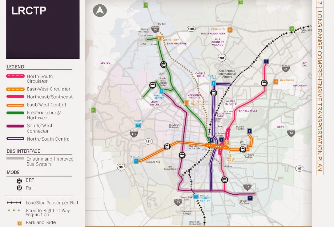
As the year comes to a close, and the streetcar is a goner, what does the future of rail transit look like for San Antonio?  If you ask the average San Antonian on what they want to see in rail transit, they'll say that San Antonio needs a subway, or a monorail system which stretches from downtown to at least loop 410 or even 1604.  They will not say Light Rail, or Commuter rail although if you show them the plans collecting dust on the Austin/San Antonio Commuter Rail, they'll, we'll all say we need it now.  The same I've notice if you take any San Antonian for a ride on a light rail vehicle in either Houston (Image 29-1) or Dallas. (Image 29-2)  Via has plans on the books for a two route light rail system, (Image 29-3) but I doubt that we'll ever see it and recently from the latest 25 year long range meetings that the Alamo Area MPO held, they extended the North/South Study area to the Stone Oak Area. 

But guess what San Antonio, We'll never ever, and I mean ever get a subway or a monorail system here because we don't want to pay for it.  If you venture to lightrailnow.org, you come across the article called "New subway (metro) systems cost nearly 9 times as much as light rail."  In this story they site Buffalo's LRT system and how light rail vehicles are using the tunnels, not the famed subway vehicles we see on TV shows.
Quote from Story:
"But the “why not a subway?” issue keeps rearing its head — mainly reflecting the resistance of the motor-vehicle-focused mindset to having urban space, especially street space, shared or usurped by mass transit operations. Overwhelmingly, surface LRT in one type of alignment or another (from street reservations to the re-use of abandoned railway corridors) has triumphed … although there have been cases where pressure to “build it out of sight” has forced new LRT startups underground (or even canceled planned projects altogether).
The tremendous investment cost of digging a subway and installing underground stations is obviously a huge deterrent to the development of such systems — both in the initial financing, and in sopping up available resources that could otherwise be plowed into vigorous expansion of the system. Buffalo’s 6.4-mile LRT line, for example, was constructed almost entirely (81%) in subway … and hasn’t been expanded one foot since its original opening in 1985."
29-2

Dallas also has a subway tunnel too and they originally planed to build a subway line only to give up and turn it into tunnel for their 90+ mile light rail system. (Image 29-2)  But when we look to Dallas for inspiration, we forget what they had and we do not, a very friendly former US Senator named Kay Baily Hutchinson to provide federal funding.  So these stories are any indication if we ever dig a tunnel for rail in San Antonio, chances are that we'll have a light rail vehicles operating in it. Another thing Dallas has going for it was a good number of abandoned rail lines crisscrossing the city to put down the light rail tracks.  San Antonio on the other hand lacks these abandoned rail lines to put any light rail system down, so as I've stated before in other blog post that if San Antonio is to get any light rail, it will mostly go down the big stroads in San Antonio as is indicated on the planning maps.


Now we hear all the time that we want a Monorail system just like, no better than the one at the 68 Worlds Fair.  Well as I looked into monorail system on Wikipedia, I found a disturbing trend.  You see, all these monorail systems seem to be short, I mean streetcar short unless they were in China.  Out of all the systems that Wikipedia list, the longest in North America is in Las Vegas. According to the Wikipedia article, it doesn't even enter the city of Las Vegas.  The most famous one in Seattle is quite short, barely a mile. So if these three systems are any indication that if we ever build a monorail system, chances are we won't get one connecting Loop 410 to Downtown.

I could waste my time and point out the failures of Personal Rapid Transit, but here's the thing, we have such a system already in place, it's called driving your car. So if someone tries to sale it to you this, chances are they're from a think tank that gave us Obamacare, like Heritage or Cato. 

Now if we really want to see how rail transit will most likely look here in San Antonio, we have to look to the City of Weird as in Keep Austin Weird for they are the closest city to us and the most similar community when it comes to driving habits and in the number of times begging the Federal Government for transit funding.  Recently Austin, had a proposition that failed that would have brought Light Rail roughly along I-35.  Now it's funny how it died because if you were to just count the votes along the proposed rail line, it would have won.  Now not all the anti rail advocates were against it because it was rail, but because where it would have not been built along Lamar.  The same sadly will happen here in San Antonio for when it goes to the ballot, everyone except the ones that live along the proposed route, will vote against it unless the voting happens to take place during a presidential election. 

Currently Cap Metro operates a 32 mile Commuter rail (Image 29-4) from Leander to Austin's Convention Center downtown, Monday through Saturday.  In 2004, Austin voted to add rail along it's freight railroad tracked it own.  Only after much delay, it started Operations in March 2010.  Since then an average of 2,500 trips take place daily and it's full of critics from on where it's located, to it doesn't serve enough people.  My criticism on it is that it don't operates to 10 or 11PM everyday.

29-3


This is what San Antonio's future rail system is going to looks like because we don't want to slow down traffic for it, we don't want to vote yes for it, and most of all, we don't want to pay for it.  The future is sighted on Via's 25 year long range plan map called the Kerrville right-of-way Acquisition.  On this map, you'll see a grey dotted line snaking from the Westside Multimodal Center to Fiesta Texas and it's not I-10, but a railroad track currently a freight line that roughly parallels I-10 and use to go all the way north to Kerrville and Fredricksburg.  Today the Rail line dead ends at the Rim, and if you go there, you'll see a rail yard full of hopper cars.  This terminal is used by Martin Marietta Materials, the company that dug out the quarries that Fiesta Texas, the Rim are currently located in.  I don't know when they'll be finished with their digging, but it should come a close some time around 2020. Once the freight operations cease, Via has plans to buy the rail line.  Whether they choose to keep it operational as a freight line like Cap Metro is up in the air, but they'll definitely peruse an option to put some type of passenger rail on these tracks.
29-4

Whether they use the same diesel Multiple Units (DMUs) (Image 29-4) as Cap Metro is up in the air, but more than likely, they will and I cannot say how many stations there would be, but I can at least guess that the stations will probably be at the following locations:
  • The Rim/Loop 1604
  • De Zavala/Huebner/Wurzbach
  • Loop 410
  • Basse Rd/Hildebrand
  • Fredricsburg Rd
  • And finally Westside Multimodal Center
29-5

And chances have it, that they will try to expand it further south along to Blue Star and down the Railroad track that currently delivers coal to the CPS coal generators at Calaveras Lake (Image 29-5) and even down to Elmendorf.  I bet once they have it operational, there will be some talk of extending it to Beorne or even Kerrville and Floresville, but I can bet it will all be TALK for the money will never ever be available unless they change the funding of this rail line from the current begging for federal and state funding to doing something that we use to do in funding transportation, which is Land Value Added tax.  We use to use this method to fund all our transportation needs way before a gasoline tax.  When they built a electric trolley line or a new rail line the property along the way would go up in value and that added value would go towards the maintenance and operation of that rail line.  I hear this is how they currently fund transit system in Japan, but that is something I cannot confirm nor provide a link to.  By judging how we currently fund our transit which is not by bus fare, but by a 1/2 cent sales tax, it don't think it's a working for everyone believes at some level that Via Sucks. 
29-6

Union Pacific Railroad will also stand in the way like one of their freight trains blocking traffic at a railroad crossing.  They dragged their feet when it came to the linear creekway trails going underneath their railroad tracks.  I'm personally counting on Union Pacific to seal those feet in cement to prevent that train from getting next to the Westside Multimodal Center, (Image 29-6) and even further to Blue Star and Elmendorf.

It will be fun to watch as the years go by hearing the same things over and over again, how San Antonio needs a subway, and lacks the political will to get rail transit done, but I can be assured up to my death, to point this out in the years to come in future blogs that isn't the case so much as your methods of selling what could be best to the general public. Chances are they'll be naysayers will say that buses can do a better job, but if that's the case then why in my video I created that it's way easier for the wheelchair to get aboard the DART Light Rail Vehicle instead of the Via Bus?  As always work to Keep San Antonio Real, realize that we all end up Keeping San Antonio Lame by making sure cars can move faster than transit, and keeping it easier to drive an automobile than riding a bicycle or walking.

Images:
29-1:  Houston Metra Downtown Transit Station Looking north.  From the video....http://youtu.be/aQmPnTjegJ8
29-2:  DART Light Rail Garland Station Looking Southwest.  From the Video...http://youtu.be/YV2ksedrTjo
29-3:  Via's 25 long Rang Plan Map.  Originally posted in Mr Nirenberg, Ever think of Walking? as Image 20-2.  Map can be found on PDF format at http://viainfo.net/Planning/LRCTP.aspx
29-4:  Austin's CapMetro Commuter Rail DMU arriving at Highlands Station.  From the Video...http://youtu.be/PmrjyXCxqzU
29-5:  A picture of the Railroad Tracks along S Presa and Southcross where currently goes out to the CPS Energy coal plant at Lake Calaveras and Dead ends just South of Loop 1604 along Old Corpus Christi Rd right Before Saspamco.
29-6.  Picture from the W Commerce St Overpass of the Westside Multimodal Center looking north referring to a prediction that UPRR will prevent any future rail from accessing the old Train Station. 

Monday, December 1, 2014

Green Lanes Aren't Enough

28-1
I've been hearing the news recently that W Commerce St out by OLLU are going to get some green painted bike lanes.(Image 28-1)  As these bike lanes are outside my map on where to live without a car, they should get the needed respect from distracting motorist, but don't count on it when you have to go around a Via bus stopped at a bus stop. (Image 28-2)  It's hard to find some data for green lanes and the only one I've found was a study in Florida a few years back.
28-2

It has been my experience that motorist do respect the green lanes more than just the white paint although the ones in Austin that I have rode in are at least 6ft wide. The problem with these lanes will not be solved by putting some green paint down, what needs to be done, is that these lanes need to wider.  Around 24th St, they're not even wide enough to be bike lanes at all.  For safe reliable bike lanes, they need to be 6ft wide, maybe 5, but these are barely 4ft which don't allow you enough room to get out of the way when a car passes. The reason why people are getting hurt using these lanes is simply because they're simply not wide enough which doesn't even provide room to maneuver out of the way of hazards that you might encounter while riding in these lanes.  Cars pass you with in 2ft as you ride in this lane, so I'm sorry to say, if you want to fix these lanes, you'll have to remove that center turn lane and put that space to the bike lane with green paint, then the bicycle lane will work properly.  

I'll give Shirley Gonzales credit for trying for she is basically the only one towards an alternative transportation future, unlike Ron Nirenberg or Diego Bernal, who claim they are but are all full of talk and lack of actions just like regular politicians.  So I say this with the rest of San Antonio Bicycling Community, thank you very much Shirley Gonzales for your hard work and may you please stay in office forever, at least one side of town will be bicycle friendly after you leave office. Although if you can, please try to change some laws, maybe some of these mistakes could be avoided in the first place.  Also the city needs to adopt NATCO standards and get rid of the law Sec. 19-66. Conformity with state manual, which forces us to use AASHTO standards, the reason why we have unsafe bicycle lanes in the first place all around San Antonio.  Keep San Antonio Lame.

Now when I first heard about the green bicycle lanes, I thought It was going to happen on the one way sections of W Commerce and Buena Vista, but for the foreseeable future, they're going to stay the same. (Image 28-3)  Now the following cross sections that I've posted (Images 28-3, 28-5, 28-7) are facing east.  I did all these measurements at the corner of W Commerce and Nueces nearby the Bazan Library.  Now the Sidewalk length isn't the same the entire stretch of W Commerce and Buena Vista, the roadway surface is.
28-3
In some of news stories I've heard, they mention Jose Carlos Macy death, but if anyone who's familiar with the circumstances of his death, will realize that is wasn't because of a stray motorist not paying attention, it was because two people were racing their cars down W Commerce, and second the tragedy was at the HEB by Zarzamora, not NW 24th St near OLLU.  Now I wrote about the tragedy that took place back in May, but I got something wrong about the size of the drive lanes which are not 14ft wide, but are actually 12ft wide. (Image 28-3)  Just by looking at the width of these lanes makes you think they're very wide and the way they manufacture cars today, it way to easy to exceed the speed limit. 
Personally, I don't ride in this bicycle lane because every time I'm crossing a major stroad like Zarzamora or Colorado, I almost get in a accident by drivers making left turns in front of me traditionally called "right hooks" which you can see the example of what almost happens to me when I ride in the left hand bike lane in the video above.  Also, it is ingrain into our society that slower traffic stays right, so somebody driving a car is more likely to expect a slow moving cyclist on the right hand side. Another thing, is the fact that these lanes don't provide much room and on any given day, you'll see someone parked in it. (Image 28-4)
28-4

Now if we're really interested in solving the problems with W Commerce and Buena Vista which is a current place where people reporting of car races, then the solution isn't painting the lane green but reducing the drive lanes to 11ft wide and putting the bicycle lane on the other side of the stroad.  Lets keep this bicycle lane on the left hand side, but instead of going with the direction of traffic, it goes against the direction of traffic.  Make this lane 6ft wide and use the two feet that we get by reducing the drive lanes by putting in a concrete median.  By doing this, anybody who has a grand ideal of using Buena Vista or W Commerce as a race way, they're in for a big surprise for when they're racing, they'll end up hitting the curb and damaging their car and hopefully, not the people who happen to be riding home on a bicycle. (Image 28-5)
28-5
28-6
One of the reasons that the bicycle lane got put on the left hand side was because Via complained about not having a place for their buses to stop.(Image 28-6)  Well, for all those who are worried about where are the buses going to stop, well here's the solution (Image 28-7) and it's nothing new for those who are frequent readers of this blog will know that the solution is a bus stop island just like the one in Austin on Guadalupe, just like the ones in the Netherlands
28-7
But don't count on this solution being built any time soon or in the foreseeable future.  You will never see this on the west side because our political leaders care nothing for the loss of life except for the person proposing the green lanes, Shirley Gonzales.  Also Via is looking at this particular Corridor for it's future light rail system which because the cars are simply more important, it will use up space for a protected bicycle lane, instead of the cars.  It is a sad fact of reality that San Antonio doesn't want a safer street, but a dangerous stroad.  The day that San Antonio sees W Commerce And Buena Vista just like the cross sections I posted is the day that pigs fly.  Keep San Antonio Lame. 
27-1
 https://www.change.org/p/mayor-ivy-r-taylor-repeal-code-of-ordinances-22-28-e-so-as-to-allow-use-and-access-of-leon-and-salado-creek-greenway-facilities-beyond-daylight-hours-in-accordance-with-22-28-a?utm_campaign=friend_inviter_chat&utm_medium=facebook&utm_source=share_petition&utm_term=permissions_dialog_false&share_id=JvxsaOGtXK

27-2
Speaking about recreation trails, there's an important petition going on right now to give people a choice in getting round town outside loop 410.  It is a petition to allow use of the Howard Peak Linear Creekways after dark.  As a person who constantly broke this law to get safely home after the buses stopped running, I can attest that the worse thing I came in contact with wasn't an ax murder, but a big ass spider with the entire web blocking the trail right underneath the Houston St Bridge by the AT&T Center.  I doubt that our city leaders will give into this because they're more serious about making sure cars have big dangerous numerous lanes instead of bike lanes, like Diego Bernal who spoke that a 1,000 miles of bike lanes where coming but when they repaved the stroads in his district, they failed to put them in or Ron Nirenberg who wants to plan for them and then leave the plan collecting dust.  I'm still going to sign it and I'm going to be publishing this petition after every story until we get a new city council in May.  I wish I wasn't right but I know for a fact that our mayor and city council will ignore this petition while people like me just go out an brake the law because I rather get a ticket, then show up on the morning news about another cyclist got hit or killed on the many stroads San Antonio.

Images:
27-1: main image for petition.https://www.change.org/p/mayor-ivy-r-taylor-repeal-code-of-ordinances-22-28-e-so-as-to-allow-use-and-access-of-leon-and-salado-creek-greenway-facilities-beyond-daylight-hours-in-accordance-with-22-28-a?utm_campaign=friend_inviter_chat&utm_medium=facebook&utm_source=share_petition&utm_term=permissions_dialog_false&share_id=JvxsaOGtXK

27-2:  The Spider Web I encountered around 3:30 AM back in July at the foot of the Houston St Bridge on Salado Creek Linear Creekway.

28-1:  W Commerce St of the bike lane next to the Valero to an entrance to OLLU looking west.
28-2:  A Via Bus stopped at the bus stop at the corner of 24th St and W Commerce showing how the buses have to invade the lane to make a stop.

28-3: A cross section of W Commerce at Nueces looking east on how it looks currently.
28-4: A picture of a car parked off the street and a car partially parked in the bike lane at Cibolo St on W Commerce looking West.
28-5:  A Cross Section of W Commerce at Nueces looking East if the bike lanes were put on either side while reducing the driving lanes.

28-6:  A Via Bus stopped at the bus stop across the stroad from the Bazan Library looking East. 
28-7:  A Cross Section of W Commerce at Nueces looking East if they had built a bus stop island. 

Tuesday, November 25, 2014

Please, Take Off Your Bicycle Helmet

At the beginning of November, I read three stories in the Rivard Report on close calls on the Mission reach of the San Antonio River.  The complaint was that cyclist are riding too fast and passing two close to people walking. In these three stories, there was talk about removing cyclist off the off the river all together except for B-cycles while others complained that we should have invested in a separated path for cyclist.  What I find interesting is that these reports are coming in right after the City removed the bike lane on S Flores which to me sounds a little more than just a coincident.  The three stories I'm referring to are (in order) Slow Down and Share the Path, Cyclists, Sharing the San Antonio River A Growing Problem, and Where Was the Planning for Cyclists on the River?

Now we can waste some money and build a separate path or ban cyclist all together which will  solve nothing especially since District 3 Council
lady Rebecca Viagran told every one when she removed the bike lanes that the Mission Reach was a good alternative bike route to S Flores, but here's the simplest thing we cyclist can do, Don't Wear Your Bicycle Helmet.  Sound counter intuitive, but in reality, wearing a bicycle helmet increase your risk for accidents.  There's a reason why in the story, Sharing the San Antonio River A Growing Problem, they mention that the SARA is considering banning all bicycles except B-cycles on the Museum Reach.  The average b-cycle rider isn't safe because they're riding a heavy bicycle, it's because they're not wearing helmets.  I ride two 50 lbs bicycle, an Electra Townie Art 24, and a Montague Paratrooper.  Both Bicycles are equipped with my backpack, chain, U-lock, and several lights and a bell.  I have on several occasions, caught up with people on road bicycles not just on my two bicycles, but on a b-cycle as well, so I can attest that the weight of the bicycle really has nothing to do with going slow.  

When you don't wear a helmet, you slow down, and you pay more attention to whats around you. We do have some indirect evidence to support this simple solution of not wearing your helmet.  In Alberta, Canada, they passed a mandatory helmet law for kids under 18 years of age.  After the law passed, they found that the number of head injuries jumps from 5% to 10% and reduce the number of children cycling. Also helmets do nothing in protecting us while riding our bicycle on the road. In actual fact, when Ian Walker risk his own life to collect data, he found out that people pass him in cars with more room without a helmet than when he wore a helmet.  And to top it off, Bike Share system are virtually the safest way to travel and guess what the average if not the majority of these bike share riders aren't wearing while riding? 

Now I know somebody reading this story will ask, "hey, what about Bono and his head injury?"  My reply is that is just one case, not statics.  If you really want to know the damage that bicycle helmets are doing, just take time out and watch this TEDxCopenhagen talk of Mikael Colville-Andersen talking on how helmets threaten the bicycle culture worldwide.


So the next time you decide to take a ride down San Antonio River, take the helmet off.  You'll end up passing other people with more room to spare.  The addition to adding more signs or building a separate path is just a waste of money, money that could be better spent by putting a cycletrack down the entire length of Roosevelt Ave or S St Mary's.  I have constantly wrote on this blog if your going to put down separate bicycle path, put it down where it is needed for transportation, not recreation and I'll continue to do so for the foreseeable future.
27-1
 https://www.change.org/p/mayor-ivy-r-taylor-repeal-code-of-ordinances-22-28-e-so-as-to-allow-use-and-access-of-leon-and-salado-creek-greenway-facilities-beyond-daylight-hours-in-accordance-with-22-28-a?utm_campaign=friend_inviter_chat&utm_medium=facebook&utm_source=share_petition&utm_term=permissions_dialog_false&share_id=JvxsaOGtXK

27-2
Speaking about recreation trails, there's an important petition going on right now to give people a choice in getting round town outside loop 410.  It is a petition to allow use of the Howard Peak Linear Creekways after dark.  As a person who constantly broke this law to get safely home after the buses stopped running, I can attest that the worse thing I came in contact with wasn't an ax murder, but a big ass spider with the entire web blocking the trail right underneath the Houston St Bridge by the AT&T Center.  I doubt that our city leaders will give into this because they're more serious about making sure cars have big dangerous numerous lanes instead of bike lanes, like Diego Bernal who spoke that a 1,000 miles of bike lanes where coming but when they repaved the stroads in his district, they failed to put them in or Ron Nirenberg who wants to plan for them and then leave the plan collecting dust.  I'm still going to sign it and I'm going to be publishing this petition after every story until we get a new city council in May.  I wish I wasn't right but I know for a fact that our mayor and city council will ignore this petition while people like me just go out an brake the law because I rather get a ticket, then show up on the morning news about another cyclist got hit or killed on the many stroads San Antonio


Images:
27-1: main image for petition.https://www.change.org/p/mayor-ivy-r-taylor-repeal-code-of-ordinances-22-28-e-so-as-to-allow-use-and-access-of-leon-and-salado-creek-greenway-facilities-beyond-daylight-hours-in-accordance-with-22-28-a?utm_campaign=friend_inviter_chat&utm_medium=facebook&utm_source=share_petition&utm_term=permissions_dialog_false&share_id=JvxsaOGtXK

27-2:  The Spider Web I encountered around 3:30 AM back in July at the foot of the Houston St Bridge on Salado Creek Linear Creekway.

Wednesday, November 12, 2014

Halloween Highlife

It's been too long since I actually wrote about the bicycle culture here in San Antonio.  Halloween or the bike rides before Halloween bring out the costumes and the fun.  The Downtown Highlife Bicycle Club Ride always brings out the most creative costumes and this year was a treat.  For those of you who are not familiar with the Downtown Highlife Bicycle Club Ride, it is San Antonio's version of critical mass which takes place every last Friday of the Month.

From Batman, to Dinosaurs to the usual dead people, everyone on bicycles was out to play.  Our ride took us first over the Hays Street Bridge and eventually to the HEB on Houston and New Braunfels to pick up some Beer and Gatorade.  Then from there, we rode to the Eastside Grave yards specifically the one Right next to the old Fredrick building to celebrate the holiday. 

As always, people start pealing off from the ride near Midnight and our final stop lead to what is hope to be a bicycle shop behind the Furniture Warehouse that is always going out of business at the corner of Pleasanton and S Flores. 

As a Trekker, my favorite costume was that of this lovely young lady wearing TOS Science Uniform.  She look like the perfect lady from the 23rd Century.  Although personally I feel that she is from the Crew of the USS Liberty which is a Saladin-class which disappeared in the
Pinchot Expanse somewhere near the First Federation.  You can find her tragic story here on Star Trek Outpost episode 47 and Episode  52.  Warning to the wise, don't listen to the whole thing from the beginning unless you have nothing to do.  ;)   Live long and Prosper. 
The Rest of the photos taken in order can be found below here.  Enjoy.