Author of Blog: Daniel Day

Showing posts with label Austin. Show all posts

Tuesday, September 13, 2016

Commuter Rail is Dead, Long Live Commuter Rail

A saying I read in a forgotten book which had a passage that said, "the king is dead, long live the king."  and if you been following the Austin/San Antonio Commuter Rail also known as the Lone Star Rail District this past year, my title fits perfectly.
57.1

Back in February 2016, Union Pacific Railroad decided to walk away from negotiation with the Lone Star Rail District. And since then, story after news story since then always had a headline saying how the project is not dead. They're several source at the end of this post.

On August 17, 2016, CAMPO (Capitol Area Metropolitan Planning Organization) board voted 17 to one against the commuter rail. But even then our local KSAT news had the biggest backer of the Commuter Rail, Joe Krier of district 9 pleading to keep the project alive. And to top it off, as I was starting to write this at the beginning of September, the Lone Star Rail District website had a list of CAMPO long range planning meetings urging people to tell CAMPO to keep the project in the long range plans. (image 57.2)
57.2
What most people don't understand, and that includes the backers, that if you want to have the commuter rail, maybe you should ditch the train and get buses running in it's place instead for the only way we're getting a commuter rail if our representatives make a federal or state law stating that Union Pacific will either provide the track or the service and that's not gonna happen ever. Cities like Atlanta, and states like New Jersey already offer intercity commuter bus services using Greyhound like buses. Houston's Metro (image 57.4) already use these type of buses for their express routes.
Now there was a time when San Antonio had such a service using buses and not that long ago. The reason why you never heard about this service is because VIA and CapMetro didn't allow these buses to use their existing bus stops and transit centers and fail to provide links to these services on their websites. There was limited bus service provided by Texas State University between San Antonio and Austin. The Alamo Area Council of Governments offered shuttle service from Palo Alto College to Poteet, Pleasanton, and Jourdation. And today in Austin the  Capital Area Council of governments provides shuttle service from several communities including San Marcos.
57.3

Texas State University use to have intercity bus service called the Bobcat Tram Interurban that between Randolph Park-n-ride, to the University with limited number of stops in New Braunfels, Kyle and Buda. Between 2007 to 2013,  you probably saw a brown bus parked across the street from Randolph Park-n-ride for VIA never allowed it to stop inside their facility. I only used the service three times. A trip to Austin cost $12 and the bicycle rack could hold three bicycles. I decided to buy a multi-ride card (image 57.3) for $40 at the time. In August, 2013, the service was canceled. When the service was canceled in August of 2013, I heard only crickets from the backers of Lone Star Rail District.

It is also worth noting that Greyhound barely provides services to San Marcos. Before Megabus took up residence at 4th and Broadway, Greyhound had several buses stopping there. Today there's only two trips available.

The service that ran from Palo Alto college to Jourdation was provided by the Alamo Regional Transit or ART. Now I don't remember when this bus was running and I never heard of it being canceled. I only found out about it when I went to use the restroom when I was out there. I never used the service because they never did have a bicycle rack on the bus. Today ART provides paratransit services to counties that are apart of the Alamo area Council of Governments.

The intercity shuttle service provided by CARTs (Capitol Area Regional Transit) run several small buses from their transit center in East Austin to several towns including San Marcos and they only run during rush hour. Also like ART, CARTs provide paratransit service to the members of the Capitol Area council of Governments.
57.4

Yes the rail would have been better than a bus, but let's face reality. Dwelling on this project is a waste of time and money. Unless laws are made from Washington DC or maybe Austin forcing Union Pacific to provide this service or the track, this dream will never be. Joe Krier with all his good intentions is simply beating a dead horse. Hey Joe, the horse is dead, long live the horse. It's time to start providing buses instead of waiting on a train in ten years that will never be.


Images:
57.1 Trinity Railway Express arriving at Victory Station in Dallas, TX
57.2 A Screenshot from http://www.lonestarrail.com/ in Sept 2016
57.3 A picture of a sample 10 ride ticket for the Bobcat Interurban bus.
57.4 A Metro Commuter Express Bus on I-69 in Houston, TX

Sources:
Despite setbacks, Lone Star Rail Project still on the table
http://kxan.com/2016/04/15/new-development-for-central-texas-commuter-rail/

Rail line from SA to Austin may be up for discussion again soon 
http://www.ksat.com/news/rail-line-from-sa-to-austin-may-be-up-for-discussion-again-soon

How Austin-San Antonio commuter rail backers plan to get back on track 
http://www.bizjournals.com/austin/news/2016/04/15/how-austin-san-antonio-commuter-rail-backers-plan.html


Future of San Antonio-Austin passenger rail could hinge on local planning group 
http://www.expressnews.com/news/local/article/Future-of-San-Antonio-Austin-passenger-rail-could-7379356.php

Derailed: Union Pacific puts brakes on Austin-San Antonio commuter rail
http://smmercury.com/2016/02/12/derailed-union-pacific-puts-brakes-on-austin-san-antonio-commuter-rail/

San Antonio To Austin Commuter Rail Not Dead Yet
http://tpr.org/post/san-antonio-austin-commuter-rail-not-dead-yet#stream/0


Wednesday, December 10, 2014

Streetcar IV: The Future of Rail in SA

29-1

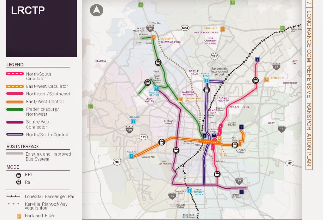
As the year comes to a close, and the streetcar is a goner, what does the future of rail transit look like for San Antonio?  If you ask the average San Antonian on what they want to see in rail transit, they'll say that San Antonio needs a subway, or a monorail system which stretches from downtown to at least loop 410 or even 1604.  They will not say Light Rail, or Commuter rail although if you show them the plans collecting dust on the Austin/San Antonio Commuter Rail, they'll, we'll all say we need it now.  The same I've notice if you take any San Antonian for a ride on a light rail vehicle in either Houston (Image 29-1) or Dallas. (Image 29-2)  Via has plans on the books for a two route light rail system, (Image 29-3) but I doubt that we'll ever see it and recently from the latest 25 year long range meetings that the Alamo Area MPO held, they extended the North/South Study area to the Stone Oak Area. 

But guess what San Antonio, We'll never ever, and I mean ever get a subway or a monorail system here because we don't want to pay for it.  If you venture to lightrailnow.org, you come across the article called "New subway (metro) systems cost nearly 9 times as much as light rail."  In this story they site Buffalo's LRT system and how light rail vehicles are using the tunnels, not the famed subway vehicles we see on TV shows.
Quote from Story:
"But the “why not a subway?” issue keeps rearing its head — mainly reflecting the resistance of the motor-vehicle-focused mindset to having urban space, especially street space, shared or usurped by mass transit operations. Overwhelmingly, surface LRT in one type of alignment or another (from street reservations to the re-use of abandoned railway corridors) has triumphed … although there have been cases where pressure to “build it out of sight” has forced new LRT startups underground (or even canceled planned projects altogether).
The tremendous investment cost of digging a subway and installing underground stations is obviously a huge deterrent to the development of such systems — both in the initial financing, and in sopping up available resources that could otherwise be plowed into vigorous expansion of the system. Buffalo’s 6.4-mile LRT line, for example, was constructed almost entirely (81%) in subway … and hasn’t been expanded one foot since its original opening in 1985."
29-2

Dallas also has a subway tunnel too and they originally planed to build a subway line only to give up and turn it into tunnel for their 90+ mile light rail system. (Image 29-2)  But when we look to Dallas for inspiration, we forget what they had and we do not, a very friendly former US Senator named Kay Baily Hutchinson to provide federal funding.  So these stories are any indication if we ever dig a tunnel for rail in San Antonio, chances are that we'll have a light rail vehicles operating in it. Another thing Dallas has going for it was a good number of abandoned rail lines crisscrossing the city to put down the light rail tracks.  San Antonio on the other hand lacks these abandoned rail lines to put any light rail system down, so as I've stated before in other blog post that if San Antonio is to get any light rail, it will mostly go down the big stroads in San Antonio as is indicated on the planning maps.


Now we hear all the time that we want a Monorail system just like, no better than the one at the 68 Worlds Fair.  Well as I looked into monorail system on Wikipedia, I found a disturbing trend.  You see, all these monorail systems seem to be short, I mean streetcar short unless they were in China.  Out of all the systems that Wikipedia list, the longest in North America is in Las Vegas. According to the Wikipedia article, it doesn't even enter the city of Las Vegas.  The most famous one in Seattle is quite short, barely a mile. So if these three systems are any indication that if we ever build a monorail system, chances are we won't get one connecting Loop 410 to Downtown.

I could waste my time and point out the failures of Personal Rapid Transit, but here's the thing, we have such a system already in place, it's called driving your car. So if someone tries to sale it to you this, chances are they're from a think tank that gave us Obamacare, like Heritage or Cato. 

Now if we really want to see how rail transit will most likely look here in San Antonio, we have to look to the City of Weird as in Keep Austin Weird for they are the closest city to us and the most similar community when it comes to driving habits and in the number of times begging the Federal Government for transit funding.  Recently Austin, had a proposition that failed that would have brought Light Rail roughly along I-35.  Now it's funny how it died because if you were to just count the votes along the proposed rail line, it would have won.  Now not all the anti rail advocates were against it because it was rail, but because where it would have not been built along Lamar.  The same sadly will happen here in San Antonio for when it goes to the ballot, everyone except the ones that live along the proposed route, will vote against it unless the voting happens to take place during a presidential election. 

Currently Cap Metro operates a 32 mile Commuter rail (Image 29-4) from Leander to Austin's Convention Center downtown, Monday through Saturday.  In 2004, Austin voted to add rail along it's freight railroad tracked it own.  Only after much delay, it started Operations in March 2010.  Since then an average of 2,500 trips take place daily and it's full of critics from on where it's located, to it doesn't serve enough people.  My criticism on it is that it don't operates to 10 or 11PM everyday.

29-3


This is what San Antonio's future rail system is going to looks like because we don't want to slow down traffic for it, we don't want to vote yes for it, and most of all, we don't want to pay for it.  The future is sighted on Via's 25 year long range plan map called the Kerrville right-of-way Acquisition.  On this map, you'll see a grey dotted line snaking from the Westside Multimodal Center to Fiesta Texas and it's not I-10, but a railroad track currently a freight line that roughly parallels I-10 and use to go all the way north to Kerrville and Fredricksburg.  Today the Rail line dead ends at the Rim, and if you go there, you'll see a rail yard full of hopper cars.  This terminal is used by Martin Marietta Materials, the company that dug out the quarries that Fiesta Texas, the Rim are currently located in.  I don't know when they'll be finished with their digging, but it should come a close some time around 2020. Once the freight operations cease, Via has plans to buy the rail line.  Whether they choose to keep it operational as a freight line like Cap Metro is up in the air, but they'll definitely peruse an option to put some type of passenger rail on these tracks.
29-4

Whether they use the same diesel Multiple Units (DMUs) (Image 29-4) as Cap Metro is up in the air, but more than likely, they will and I cannot say how many stations there would be, but I can at least guess that the stations will probably be at the following locations:
  • The Rim/Loop 1604
  • De Zavala/Huebner/Wurzbach
  • Loop 410
  • Basse Rd/Hildebrand
  • Fredricsburg Rd
  • And finally Westside Multimodal Center
29-5

And chances have it, that they will try to expand it further south along to Blue Star and down the Railroad track that currently delivers coal to the CPS coal generators at Calaveras Lake (Image 29-5) and even down to Elmendorf.  I bet once they have it operational, there will be some talk of extending it to Beorne or even Kerrville and Floresville, but I can bet it will all be TALK for the money will never ever be available unless they change the funding of this rail line from the current begging for federal and state funding to doing something that we use to do in funding transportation, which is Land Value Added tax.  We use to use this method to fund all our transportation needs way before a gasoline tax.  When they built a electric trolley line or a new rail line the property along the way would go up in value and that added value would go towards the maintenance and operation of that rail line.  I hear this is how they currently fund transit system in Japan, but that is something I cannot confirm nor provide a link to.  By judging how we currently fund our transit which is not by bus fare, but by a 1/2 cent sales tax, it don't think it's a working for everyone believes at some level that Via Sucks. 
29-6

Union Pacific Railroad will also stand in the way like one of their freight trains blocking traffic at a railroad crossing.  They dragged their feet when it came to the linear creekway trails going underneath their railroad tracks.  I'm personally counting on Union Pacific to seal those feet in cement to prevent that train from getting next to the Westside Multimodal Center, (Image 29-6) and even further to Blue Star and Elmendorf.

It will be fun to watch as the years go by hearing the same things over and over again, how San Antonio needs a subway, and lacks the political will to get rail transit done, but I can be assured up to my death, to point this out in the years to come in future blogs that isn't the case so much as your methods of selling what could be best to the general public. Chances are they'll be naysayers will say that buses can do a better job, but if that's the case then why in my video I created that it's way easier for the wheelchair to get aboard the DART Light Rail Vehicle instead of the Via Bus?  As always work to Keep San Antonio Real, realize that we all end up Keeping San Antonio Lame by making sure cars can move faster than transit, and keeping it easier to drive an automobile than riding a bicycle or walking.

Images:
29-1:  Houston Metra Downtown Transit Station Looking north.  From the video....http://youtu.be/aQmPnTjegJ8
29-2:  DART Light Rail Garland Station Looking Southwest.  From the Video...http://youtu.be/YV2ksedrTjo
29-3:  Via's 25 long Rang Plan Map.  Originally posted in Mr Nirenberg, Ever think of Walking? as Image 20-2.  Map can be found on PDF format at http://viainfo.net/Planning/LRCTP.aspx
29-4:  Austin's CapMetro Commuter Rail DMU arriving at Highlands Station.  From the Video...http://youtu.be/PmrjyXCxqzU
29-5:  A picture of the Railroad Tracks along S Presa and Southcross where currently goes out to the CPS Energy coal plant at Lake Calaveras and Dead ends just South of Loop 1604 along Old Corpus Christi Rd right Before Saspamco.
29-6.  Picture from the W Commerce St Overpass of the Westside Multimodal Center looking north referring to a prediction that UPRR will prevent any future rail from accessing the old Train Station. 

Thursday, October 9, 2014

Another Useless Bicycle Lane

22-1
As I continue to write this blog, I constantly show how the City of San Antonio and it's political leaders aren't interested in providing anything in the way of transportation improvements unless it has at least 4 wheels, an internal combustion engine and helps keeps the myth going that global warming is a conspiracy. 

Back in April, I wrote the post Useless Bicycle lane, showing how three bicycle lanes in the city are completely useless in providing actual protection.  They were S Main Ave, S Pine St, and Elmendorf St on the west side.  Since my publishing of that story several things have changed and I can add two new ones to that list which are Village Parkway on the Far West Side, and Diana on the East Side. 

I think a lot of you are asking what constitutes a Useless bicycle lane, and this is how I come to figure out that conclusion.  The first thing I go by the Dutch principal which you can see below this paragraph in this video explaining when and where you put one and a quote of Jeremy of the Critical transit blog Transit Tip #14 which states: "There’s a tendency among bike advocates to champion the delineation of a “bike space” even without any actual space being created. You know, “if there’s room for a bike lane” without changing anything else on the street". When the Dutch put down a bicycle lane (and they do just like us Americans) or a cycletrack, they put them where they are needed, like places where cars go faster than 30 KM per hour. For us Americans, that roughly 20 Miles per hour.  There's a reason why nearly all school zones are 20 miles per hour, because that is the safest, fastest speed possible to prevent collisions and reduce harm when collisions occur.  The Dutch put those 20 mph zone not just in school zones, but down residential streets.  You also see 25 MPH in the neighborhoods of Terrell Hills and Alamo Heights, which makes me think they sort of get it.  

The  Improvements

22-2
Back in July, S Main Ave (Image 22-2) got a new paint job, and this time taking into account of the parking occurring on the street.  Before, they had a bicycle lane with parked cars, (Image 22-1) now there's a bicycle lane, a parking lane, and smaller drive lanes.  It's not perfect, but it's better than the last time.  I call these type of lanes, Double Edge Swords for you have a space to ride, but when a parked car and a vehicle is passing you, you have no escape route.  So if your ever riding down S Main or any other street with this type of paint job, simply ride in the parking lane when there are no parked cars and treat it like a buffered bicycle lane that is currently popping up all over Austin. Take it from me, you'll feel better in doing so, and safer. 

Elemndorf out by Woodlawn Lake also got a small improvement, that of a 25 MPH sign and as I was riding down it, I notice that most of the cars were following it too.  The bicycle lane with parked cars in it is still there, but the wasted paint it's fading day by day. 

New Useless Lanes

22-3
Village Parkway on the far west side off of Culebra Rd is one of these useless bicycle lanes. (Image 22-3) With cars not just parked in it, but it is down a residential street where cars should be traveling at 20 mph instead of the 30 mph posted. To add a touch of stupidity to this useless lane, the neckdown at the corner of Cross Springs and Village Parkway (Image 22-4) was poorly built. You would think that if the city of San Antonio is going to build a traffic calming device, they would do it right in the first place and actually calm (slow) cars, but no, they did not.  You see the ideal of having these neckdowns is to slow vehicles while making right turns. 
22-4

Now I wouldn't be complaining about the neckdown along with the bicycle lane, (Image 22-4) but since they build it with rainwater runoff being more important than having adequate protection of the cyclist.  Common sense should have told the idiot who designed it that cyclist and cars don't mix and should have had a 5ft opening through the neckdown. Or better yet, realize that the bicycle lane is useless in the first place and build the neckdown out to the place where you see the outer stripe of the bike lane, but no, they had to reroute the bike lane around it bring it into close contact with impatient drivers. The good news about all of this is the bicycle lane on Culebra and although I think removing the right traffic lane and putting down a protected cycletrack would be better, it's better than nothing. 
22-5

Diana on the East side has one of these useless bicycle lanes. (Image 22-5)  It's a very wide street and does nothing for safety of the pedestrians or cyclist.  It does however provide a small space for people walking along the east side of the street because the city felt that not having a sidewalk would help people not fall into the ditch that runs along side Diana.  There's barely enough traffic along this street to really warrant the width of the street or the bicycle lane there except when the school is ending or starting the day. This bicycle lane doesn't need to be on Diana, but should have been placed on Rigsby where the fast moving traffic on that stroad should have a least a bicycle lane or better yet, a protected cycletrack

The solutions that I come up are something that the city cannot do because that would slow down cars, and we just can't do that.  One of these solutions is changing the law that forces the CMI people to use AASHTO standards which are great for long distance interstates instead of the NATCO (National Association of City Transportation Officials) standards that were developed for urban areas and looking in there to determine how wide the street needs to be because this road surface needs to be narrowed with wide sidewalks along both sides with planted Pecan trees between the sidewalk and the street. This would do wonders for the property values and provide shade along the street along with 25 mile per hour signs would also do good.  Maybe a parking lane along the elementary school and the city park would also be good instead of a useless bicycle lane. 

Now there are others that I've been considering to be useless such as SW 19th St, Timberhill, Rittiman, and even Semlinger Rd, but I'm not yet to declare these useless because traffic volume is just enough to consider their need, but what's the point, after all people consider this space to better use by parked cars than a space for a cyclist to be.  Keep San Antonio Lame. 

Images:
22-1: A picture of S Main Ave looking north back in April, 2014
22-2: A picture of S Main Ave looking north back in August, 2014
22-3: A picture of Village Parkway looking west
22-4: A picture of the neckdown at Cross Springs and Village parkway looking east.
22-5: A picture of Diana looking north.

Wednesday, October 1, 2014

San Antonio Barely Makes the List

21-1
Every two years, Bicycling Magazine creates this list of the 50 top bicycle friendly cities in America published in Oct 2014. We're down to #48 (Image 21-1) from #47 back in July 2012 (Image 21-2).  83 Miles north of us, is the Weird city of Austin, and they're also on the list at #11 from #13 back in 2012 (Image 21-3).  Another blogger recently wrote about this in Fit In S.A. saying quote: "The completion of the Mission Reach is one of the reasons San Antonio made it onto the list." That's the only reason why we're even on the list folks because of a "recreational trail" and with B-cycle serving it.

21-2
Don't get me wrong I love the Mission trail, but unlike back in 2012, Bicycling Magazine also mentioned the bicycling community quote: "An emerging cycling-friendly vibe fueled by 1,700 miles bike network of lanes, paths, and sharrows."  What the hell happened, oh, that's right, the City council voted for the removal of such a system with only one member, Shirley Gonzales voting to keep it.  Also happened was that Boneshakers got it's property cut off by the San Antonio River Authority, and they went out of business at their river location and their Hays Street Bridge location. Cars still park in the cities only cycletrack on Avenue A, and to top it all off, the city don't give a damn about cars parked in your bicycle lane.

21-3
But I don't think it is because of our expanding B-cycle or a completed recreational trail that we made the list, in my own opinion I believe it is the fact that San Antonio has a rich bicycle culture.  It is you the people who come out to Frankenbike, Downtown Highlife Bicycle Club Ride , the Zombie ride, and all the other rides in San Antonio.  It's bicycle groups like The Wild Dawgs, the Street Ratz and many many more.  It's those who get on their bicycle or as I like to say "put the fun between your legs," and ride everywhere just because.  You see it every First Friday with people just riding down S Alamo and going to the bicycling friendly places like Alamo Street Eats, and other bicycle friendly places like the Bottom Bracket Social Club.

21-4
It's funny as I look back at our position of #47 and see an echo of it through the Tweet of Diego Bernal of District 1 claiming how San Antonio is planning to 1,700 miles of bike lane (Image 21-4).  Just like Ron Nirenberg saying how we need a plan to improve transportation in San Antonio, it goes to show you how useless it is to have a plan if your not willing to follow through. 

Recently, Several Stroads where recently repaved in District 1 near downtown.  Here on Colorado St, they finish repaving it and repainting it (Image 21-6).  According to the Bicycle Master Plan, Colorado St from I-10 to Caesar Chavez (Image 21-5) has a plan for a road diet similar to what was done to S Flores. But as you can see in my recent photo of the place it has the same configuration that makes a stroad a stroad.  Hey Mr Bernal, where's the bike lane that you promised? (Image 21-4) 
21-5
21-6

But lets face the reality here, San Antonio is too stuck behind the wheel of a car to ever envision a Netherlands network of bike paths and Cycletracks or ever have light rail transit.  Although the city is constructing a cycletrack in front the Henry B Gonzales Convention Center along I-37, chances are it won't be used like the city ever intended because there's no signs, sharrows, or painted green like you would see on a similar path in Austin (Image 21-7).  If things don't start changing, we will not be on the Bicycle Magazine list come 2016 while I'm betting that Austin will be comfortably in one of those top ten positions because they're committed to building more bus stop islands like this one on Guadalupe St (Image 21-7).  Keep Austin Weird, Keep San Antonio Lame.
21-7
Images:
21-1:  A picture of the Bicycle Magazine October 2014 rating of San Antonio, TX as #48 of one the top 50 Bicycle  Friendly Cities in the USA.
21-2:  A picture of the Bicycle Magazine July 2012 rating of San Antonio, TX as #47 of one the top 50 Bicycle  Friendly Cities in the USA.
21-3:  A picture of the Bicycle Magazine October 2014 rating of Austin, TX  as #11 of one the top 50 Bicycle  Friendly Cities in the USA.
21-4: A Screenshot of my Facebook Re-posting of Diego Bernal's FB posting of how San Antonio has 1,700 miles of bile lanes planned and my friends response to his comment.
21-5: A Screenshot of page 28 of the Bicycle Network PDF of the Bicycle Master Plan.
21-6:  Colorado St Looking North one block north of Martin St.
21-7:  The Bus Stop Island on the Guadalupe St Cycletrack in Austin, TX.